 Over Stanna’s right shoulder is the back side of Mont Blanc about 120 miles of passes and valleys away from the Matterhorn. Great to see from beginning to end in one view.
Monthly Archives: September 2013
Matterhorn


Last Pass
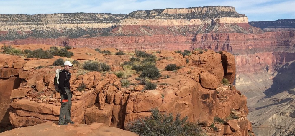
 Today we finished the last pass between Gruben and St. Niklaus, where we encountered a little bit of ice and snow on the ground. Got an early morning start because today’s hike was slated to be 7 1/2 hours over one pass and down one very very long hill into St. Niklaus. Unfortunately because of the earlier day’s rain and snow there was much mist and fog coming up the slopes from the valley so we couldn’t see all the beautiful views and vistas until midway through our walk. The icy cold temps kept us moving right off the summit where we only paused long enough to take the above photograph, thanks to a fellow hiker.
 It stayed foggy and beautiful views were invisible for much of the next couple hours off of the pass. We traversed in talus and boulders in the mist with extra concentration anyway, so probably views didn’t matter. Every once in a while a vague hamlet or farmhouse would appear that was never clear enough to take a good photograph.
 Then rounding the shoulder or ridge when we were least expecting it, we could see, far down in the valley, some of the communities on the valley floor on the way up to Zermatt. High up across the valley we could see a humongous glacier forming, never quite clearly knowing what we were looking at. Once we got the map we realized we were looking at the glacier on Dom, the highest mtn within Swiss borders, with it’s majesty dominating the lower Zermatt valley.
 Descending toward the St. Niklaus area we walked along a long wall that is known as the Blumenalpinweg, the Alpine Flower Walk. Being mid-September all the flowers were gone but the placards still showed the big variety of wildflowers that grow along that walk. Arriving in Jungen we still had an hour and a half more to descend and you could just start to make out the houses and railroad in the valley.
 Zermatt is now only 11 miles up the valley from St. Nicolas.
Gruben
 Today we tried to beat the forecast weather of afternoon thunderstorms over the pass. Starting high from the Hotel Weisshorn gave us an advantage of only having to climb about 600 meters in our 4.5 hour hike. The hike was billed as having beautiful views but we didn’t see much of those views with fog and clouds rolling darkly across the peaks.
 There wasn’t much to photograph with low clouds or fog. Let’s just say that we were going from the Whitehorn to the Blackhorn hotel. Below is a photo was sitting in our room waiting for dinner. As you can see it was a little cold in the room but then the soup and salad first courses for dinner were excellent.


131 Year Old Hotel

This afternoon we checked into a famous 131 year old hotel, high above the collective valley communities of Grimentz, St. Luc, Mission and Ayer, called the Hotel Weisshorn, perched on the edge of a cliff with exceptional 360 degrees views. Some of the hallways have the original paint scheme, while the rooms have been re-panelled. The floors are wooden planks and interior stairways are original stone.
 Furnishiings for the rooms are spare and showers are located in one room modified for the purpose. WC is located, one for each floor, on the mid stairwell halfway between floors. There is a lovely outdoor terrace at the hotel entrance, where we sat in the sun enjoying the views this afternoon along with the other 8 rooms of guests for this evening. As we eat dinner we watch the street lights in each of the small villages light up like Christmas tree lights or brunt embers in the farthest reaches across the valley.
 The village of Ayer was an unexpected treat because we had not planned to climb thru this village on our way to the Weisshorn. So many old wooden timber houses, it was hard to decide which to photograph. Situated on a slope just below the long hanging valley, atop which they grazed the milk cows, the town was crowded with granaries and barns for winter housing of the live stock. If you haven’t noticed, geraniums are de rigeur in all forms and bunches in planters, hanging baskets and pots.
 As in every village the steepled church stands prominent and centered on the narrow streets. This community must have raised considerable grain in the alps above because they had a still functional large waterwheel that in days past drove a large flour mill. Water for the mill’s wheel was piped from alps above the village.
 Because it had rained the night before, the morning hike started in the rising fog of dampness in the valley. The hike was necessarily steep and we spent much of the morning in deep forest. Slowly the clouds revealed the surrounding mountains and just about the time we stopped for lunch we first heard and then a short while later were treated to seeing a Swiss Air Force air show. Two F-18’s did repeated barrel rolls and loop-to-loops in and out of the clouds above us. When you couldn’t see them you could still tell their aerobatic maneuvers by the tremendous sounds from the accelerations they produced.

Grimentz
 According to my GPS we’ve completed 76 miles of the Haute Route. Today we climbed about 4000 feet and descended almost 4,500 in a little over 11 miles. We are averaging just under 11 miles per day which doesn’t sound like much until you take elevation gain and loss each day. Every day but the first included a pass to go over, and some days we went over two or three.
 Here’s Stanna completing today’s pass, Col du Torrent. We seem to have dropped many of the hikers today because we jumped over a normal stopping point on account of our trip being 12 days and others are doing 14- and 15-day tours. The only through hiker we saw today was coming the opposite direction as he was trying to combine two days into one, and we saw him late in the afternoon. Since it was Sunday we did see a number of day hikers as we got closer to the lake on our descent, but other than that it was pretty much just us on the trail.
 We have seen quite a number of high Alpine Lakes, many of which have hydroelectric dams. Considering the number we’ve seen, Switzerland must export electricity. Most of the lakes that we have seen have been runoffs from the various glaciers and are milky white in color. Yesterday’s lake and dam was said to be the largest producer of hydroelectric power in Switzerland. The lake we saw today was azure blue or turquoise in color and was very different considering it’s size.
 One of the towns we passed through, or I should say village, had quite a collection of vintage wooden houses. Every one was in fully restored condition and I’m sure that McKenney would be absolutely fascinated by the carpentry techniques used. It’s easy to tell the granaries as they all have large flat round stones between the foundation and the floor joists in order to keep varmints from getting up into the wooden grain storage houses. We’re still trying to figure out why some houses are half stone and half wooden. And by half-and-half I mean a four-story house might be built four stories of stone right next to four stories of timber and all connected with the same roof. We’re wondering whether or not many of them are now second homes, as Stanna said maybe they were always second homes when they had a summer house with the cows further up the mountains.
Today the weather came in and we started our hike in low clouds or fog when we were in the low lands. Real quickly we got up above those clouds and could look down on them, but it wasn’t long before they started rising with the heat and we were hiking in fog for about half a day. Fortunately we beat the rain, arriving at our destination just as the rain started.

Ladders
 Last night’s stay at the Praflaurie hut was super crowded with about 70 hikers. Amazing considering how virtually remote it was and how far it is to get there from Verbier. Actually there were two routes and we took the more scenic and exposed route which afforded the rare opportunity to see both Chamois and Ibex in the wild. I’ll have to do some photoshop cropping to get them to show up in the photos before I can prove our proximity.
 Our room was a double bunk bed with a Russian couple below with whom we never spoke a word but exchanged some smiles. Other rooms had 12 and (we heard) as many as 16 bunks. Dinner is served family style, with soup then salad and then a goulash with mashed potatoes. Surprisingly there was plenty and even seconds and thirds. Construction of the hut was reasonably new but they only provide 2 pay showers and two toilets for that many bunks. Needless to say it was quite interesting to see the line coming away from the bathroom.
 Weather has still been wonderful but stormy weather is forecast. We are about three valleys over from the Mont Blanc massif and can only see the backside when we summit a pass. Another interesting fact about the hikers is that they have solidified into mostly English speaking variety. The French contingent has mostly turned at the Tour du Mont Blanc trail and now it’s almost all English on the tracks. The real interesting group is from Seattle with an 81 year old couple and their sons and families, 11 in total. Of course there are several versions of American tours on the route and they vary from supported luggage and lunches to the guided versions.
 Today’s route featured a Hobson’s choice of 70′ vertical ladders or a long loose gravel climb over the adjacent Summit, followed by a 1000 meter descent in to the town of Arolla with it’s three hotels and single ski lift. The small town square was filled on my arrival with another trail runner’s finish line. Seems to be quite popular, this ultra trail running around here. The field must have been easily 4-500 runners in all categories.

Verbier
 Today’s hike was less mountain climbing and more rural towns and trails: our first day on easy trails marked by yellow signs rather than the red and white trails denoting difficult. It is very interesting to walk through, up and down the narrow villages with wooden buildings probably 500-years-old mixed in with contemporary. Fortunately the yellow trail signs are ubiquitous both inside the villages and out on the trails, anywhere there’s a fork in the road there is generally a yellow trail sign pointing the direction you might want to go.
 Just to be certain, Stanna pulls out her iPhone and checks the Kindle version of the hiking guide to make sure we’re on the right track. Kev, the author of the trailguide, has evidently walked every mile or kilometer of this trip because he knows all the forks and can tell you just when a decision is going to come up. His remarks about this particular day’s walk is that is it is “more of the every day life of the Swiss”, because we were walking through farmland and thru some industrial areas like quarries. We still had quite a bit of it elevation loss and then significant gain to Verbier.
 Tonight we are once again in a hotel but this one with a beautiful balcony overlooking the entire town, which is a famous Swiss ski town probably an equal to Vail Colorado. Interesting to note, we heard that this is the end of the season, but this is the first time we’ve been in large hotel where we’re
the only guests for the night. They are sending us to a restaurant across the street for half board dinner as their dining room is closed.


Fenêtre d’Arpette
 Second pass behind us.This is a big one, we’re glad to have it over. Yesterday was more mileage, almost 20 km or 12.1 miles, today was much steeper in terms of altitude and climbing, as this pass was much tougher than the day before. Many more serious hikers on it because it was a combination of two different trails. The Mont Blanc trail and Haute Route both share the same leg over this Fenêtre d’Arpette. Only 8,800′, about the height of Purgatory base, but the gain was 4,600′ about half of it thru boulder fields which makes for slow going.
 There were plenty of other hikers going both ways on the pass, so it was hard to get our “moment” under the signpost. Once again the weather was absolutely perfect, crystal clear blue skies with nary a cloud in sight.

This last photo is a picture looking back up to the pass while going downhill, it truly is a window. We’re now in a tiny Swiss hotel in town called Champex-Lac looking forward to our half– pension dinner and a comfy night’s sleep.
Col de Balme

Lunch on top of the pass, Col de Balme, which is the border between France and Switzerland. Roughing it with salami, cheese and a loaf of multigrain bread and a view only seen on Swiss calendars. We have absolutely perfect weather without a cloud in the sky. Our day was supposed to be 6 hours and 15 miles, but I think we ran a bit over as the downhills were slower than the guide book.

The traverse off the pass took us a long way over to two different glaciers, the Grand Glacier and the Trient. You could feel the temperature changes each time we approached a glacier drainage.

Just below one of the Swiss Alpine Club huts was a steep inclined walkway across a vertical rock wall. A fixed cable along the wall looked to be a necessity if and when the rocks were wet.

Tonight is our first dormitory-style hotel that is fully booked with hikers, as the Col de Forclaz Hotel services both the Haute Route hikers and the Tour du Mont Blanc hikers.

Argentiere
 Argentiere, silver platter in French, is just uphill from Chamonix, about 9 km to be exact. From this village we head over the Col de Balme. The guidebook says “allows you to get into your stride with ease”. Let’s hope so.
 We had a leisurely start this morning as we have nine KM total for today’s walk, a mostly forested walk along the stream coming down from the higher passes. There were number of people and mt. bikes on the trail most of which were going downhill since you can ride the train up to the top and walk or ride back down. We haven’t seen any other trekkers as of yet although we seen a number of young climbers waiting at the various bus stops along the road with their gear and ropes hanging off their backpacks.

We’ve taken advantage of the upscale facilities in the last two hotels we stayed in. They both had pools as well as Jacuzzis (which are not hot tubs because the Jacuzzi’s aren’t that warm). The current hotel we are staying in has a stainless steel pool as well as a stainless steel hot tub. The pool is half inside and half outside, and makes me want to install one in our condo.


Chamonix

This mural and the one below tell in one dimension what is Chamonix’s history is all about. What’s most hard to believe is that the same time of the Civil War 1865, the first ascent of the Matterhorn was made by an Englishman. His French guide was unfortunately killed on the way down and remains a hero of this town.

We really enjoyed getting here as well. The train ride north around Lake Geneva down to Martiny and then taking a cog railroad up of the mountainside thru and along a number of really interesting and beautiful Swiss towns to the French boarder, and then on into Chamonix. The town was filled with ultramarathon runners, actually ultra trail runners. The runs were four distances and the longest of which was 300 km with 24,000 meters of ascent. I suspect some of Silverton’s “hard rock 100” runners were competing here as well.
Our hotel had a rooftop pool sauna and Jacuzzi available to us as soon as we arrived. So we took advantage of that and the same time watching the clouds run past all the glaciers in the Mont Blanc cirque. Stanna’s plan to keep me from seeing menu prices is working really well, she got rooms that include dinner and breakfast. Our first dinner was outstanding.

Tomorrow we start hiking in earnest. We’ll turn the Spot Locator on should you want to follow us on our track.


