Sargans to Weisstannen

IMG_8645.JPG

We bested Kev-time today hiking the 5.5 hour Wanderweg (hiking trail) to Weisstanen in just over four hours. Perhaps it’s just because we were fresh and the climb was only 3,100′, but beating the hiking author, Kevin Reynolds, time for a hike is a big deal according to Stanna. Last year we were mostly longer than his posted times.

IMG_0609.JPG

For those of you curious enough to click on the Spot Locator track you’d have noticed a big jump in the track from the San Juan’s to the Swiss Alps. If you’d zoomed in on the eastern end of the arch and maybe even changed the default map to satellite, you’d see us amble up the Weisstannen (means Silver Fir) valley.

IMG_8680.JPG

We’re currently bedded at the Gemse (Chamois) hotel, one of two hotels in this very small, as in less than 20 houses, alpine village. It’s an interesting choice of name since the region is famous for introducing the Steinbock (ibex) to the area in 1911. We’ve seen neither, but we’re still below tree line.

IMG_8683.JPG

It rained for an hour during this first morning so we proved we’d not forgotten any rain gear, both of us donning jackets and rain pants. Forecast is mostly sunny for the next five days, so we’ll see how accurate the Metro Weather forecasts turn out to be.

IMG_0003.JPG

No other hikers on the trail that we saw, however a solo European guy from our hotel this morning showed up at this one as well this afternoon. Trail was mostly in heavy woods with one long wooden stairway out of a ravine. We lunched on our salami, cheese and loaf at a crossroads water trough common throughout Switzerland.

IMG_8686.JPG

Via Alpina

Via AlpinaLabelled

Off to hike another Swiss trail, this one’s called the Via Alpina and runs from Liechtenstein to Lake Geneva. We’ll only be doing about 16 days of the route, plus 2 layover days to revisit several places Stanna first visited 2 years ago.  Via Alpina is north of the Haute Route trail we hiked last year, a little longer and is said to be slightly more moderate.

PacksLabelledThis year we’re scaling down our packs to Talon 22’s since we can get all our clothes and necessities into the smaller volume packs.  The weights are almost the same at 10 and 12 pounds.  Only downside is that shopping and gift buying options are reduced to the space which the soon-to-be-depleting vitamins currently occupy.  I’ve got just enough room for a baguette, cheese and salami and Stanna has a little room for chocolate, so I guess Stanna could still buy a little fabric or thread at the end of the trail.

For anyone interested in learning more about hikes in Switzerland we recommend checking out the Switzerland Mobility site.  They list all sorts of routes and even show accommodations along the way.

Pear Lake Loop

IMG_7327We snuck in one more quick trip into the Weminuche Wilderness this last three days.   I wanted to get back to a spot I’d visited several years ago, when I first returned to backpacking and ultralight gear.  Mountain View Crest Overlook is just south of the Weminuche’s 14’ers and the Chicago Basin and offers an outstanding view directly across from that range at almost 13,000’.

PearThere are a number of lakes in the immediate area and we visited at least four of them plus a number of unnamed ponds.  Our destination was Pear Lake where we set up camp the first day and later dropped further down in the afternoon to visit Webb Lake and it’s view up Needle Creek to Chicago Basin proper.

Forecast was “mostly sunny” in Durango, but it never quite cleared at our elevation and remained cool such that I never separated the zip-off portion of my pants, although the first night never dropped below 41°.

SANY0049Since this loop was short in comparison to many of our adventures ,we had plenty of time for fishing (I actually bought a license: $1 for the year includes Search and Rescue rider, but not transport), and exploring.  In addition to looking for new trails and routes we spent considerable time rehabilitating campsite fire-rings.  Often times there are several rings in one campsite, or in totally inappropriate spots like the SANY0035one at Ruby Lake where there was no firewood and was technically in a prohibited watershed.  After disposing of 18 one-gallon bags of ash and charcoal we restored the pit with a similar number of bags of fresh dirt (thanks to prairie dog mounds) and a few native plants.  And it allowed for a third tent site.


P1390594MikeRylerRubyMike had great luck fly fishing, and no luck teaching me to “clock to 11PM and don’t bend your wrist”.  He caught and released 12 fish before me and one after, while I caught only reeds and weeds.

Our hiking partner and ultralight guru, Will Rietveld, Southwest Ultralight Backpacking, was reviewing three new lightweight pack prototypes, so we switched off each day, gave unhelpful comments, andSANY0012SANY0054 modeled for his analyses.  Fun to see what’s in the pipeline in the way of packs and even more fun to hear and share tips and tricks on cutting weight down and making gear serve two or more purposes.  We couldn’t help suggesting that Will should show how he tests all the packs on a trip like this by trying them all on at once.


Next day was even more leisurely, visiting other lakes, fishing, checking campsites and exploring the area.  We only managed 16+ miles but climbed and descended 6,400’ in this tight mountainous region.  If the weather were less cloudy our photos would be worthy of publishing as the views were spectacular.

P1390605

Williams Creek Loop


WilliamsCreekLoopMike Taylor and I planned a three-day backpacking trip in the Weminuche north of Pagosa Springs, an area that neither of us had hiked before. We watched the weather and delayed one day to get the best window for our trip, which turned out perfect even though the morning we left the National Weather Service predicted late afternoon thunderstorms for only our section of the San Juan Mountains. The clouds did form but not a drop of rain until late the second night when we were well out of the high country.


IMG_7214Just reaching the Williams Creek Trailhead was a pleasant surprise because the rolling hills of combined National Forest and remote ranch lands north of Pagosa are a delight to drive through. This is definitely horse country as evidenced by the “Campers with Horses Only” campground designation at our trailhead. (There are numerous other unrestricted campgrounds spread around the area in close proximity).


SANY0001


Mike and I have hiked a number of trails this summer as WIS volunteers and we’ve experienced, and come to expect, recording a high number of downed trees and water erosion along the trails, but we were pleasantly surprised to find not a one for the first 9 miles.  We only saw 2 groups of backpackers the first day (one couple from Ouray with a “borrowed” llama who knew mutual friends).


IMG_7197


We camped right at the edge of tree line due to the weather report but could easily have camped, with ample water available from several small lakes, just below the Continental Divide at 12,200’.  Mike enjoyed trying his new Hexamid Duplex tent with Ryler his lab, and it was fun to see the two generations of zPacks tents set-up side-by-side.  His has new features I’m envious of: double doors, higher roofline, a sewn-in Cuban fiber floor and generous vestibules on both sides. (Don Ahlert had the same tent on the Great Divide.)


SANY0009


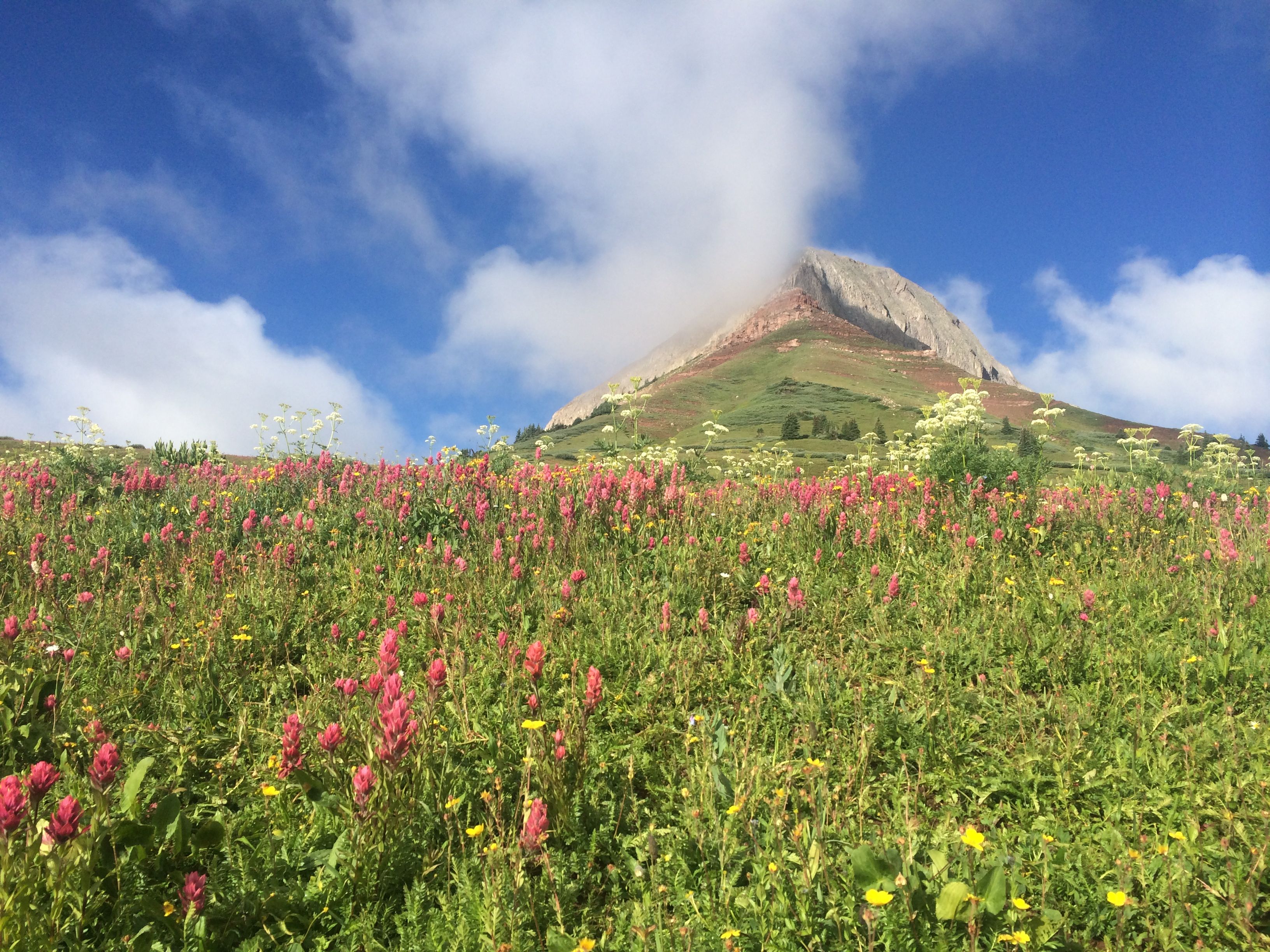
The views on this crystal-clear deep-blue-sky morning along the Continental Divide Trail portion of the Loop were spectacular: looking south all the way to New Mexico and north directly into the Weminuche’s isolated Squaw Valley and to Colorado’s most remote 14ers, Sunlight, Windom, and Eolus as well as the Grenadier’s.

IMG_7230We’d planned two nights in the high country, but found on descending the Cimarrona Creek Trail there were no flat spots for two tents, let alone proximity to fresh water, so we soldiered on and on and on, all the way to the valley below, 16 miles before we could camp.  Neither of us believed there wasn’t a spot “just around the bend”.  The nine-mile 4,100’+ climb the day before was plenty, and this turn of events on the never-ending downhill gave us little respite except for one photo op under an unusual (for the San Juan’s) conglomerate arch (photo above).

SANY0006I had the worst cramp ever after dinner the first night when the temperatures cooled down.  Just a minor move while reclined on my mat brought on a massive inner right thigh cramp that levitated me up off the ground in pain.  After two minutes of hollering like a wimp, I remembered that I needed to do some stretching after that 4,100′ climb.  Mike caught me in the downward dog, which will please my yoga teacher when she see this photo.

IMG_7217

Mike felt like this was prime moose country and validated the thought when he came upon a juvenile moose track at the top of Squaw Valley.  Moose were transplanted into Creede nearby a number of years back and it’s unusual to see one in the Weminuche.  We did see a number of deer and some young elk and only one bear track.

Supermoon with McKenney’s

IMG_7180We only live 80 miles apart, however the three mountain passes keep us from getting together more often. We’ll make a run south to Farmington 50 miles and only an hour away, but to go north 80 takes 2 ½ hrs one way and a lot of planning since it’s an all-day commitment no matter which direction you start out.

IMG_7178
What made this last weekend in Ridgway a special treat was that we also visited with Kurt and Carol who were in town for the Ridgway Art Festival.  They only live 7 miles away and we don’t often get to spend an evening with them as our summer schedules don’t always mesh.  Fortunately we do see them individually on a more frequent but shorter basis in town and occasional potlucks.
The McKenney’s Ridgway house, garden and projects are always a joy and marvel to see, we wish we were closer to help or appreciate the work they’ve put into their home and IMG_0691grounds. Tom’s current and lingering project has been the “detached” shop and it’s Belvedere / Mirador atop the shop.  Winter, surgery and recovery have no doubt frustrated the progress, nevertheless daily improvements add up to major changes when we only visit several times a summer.
IMG_0699McKenney gets the credit for the bricks and mortar improvements, but Martha Ann’s decoration, polish, green thumb and artist’s touch cover the framework and infrastructure he’s built.  The garden is the jewel and the Aspen grove park is an in-town wonder on a quarter of the lot.
IMG_7175We weren’t encouraged to bring a thing and Martha Ann regaled us with a white tablecloth Aspen Grove dinner featuring homemade cheese, a tomato torte, mostly home grown organic salad and delicious local peaches with heavy cream for desert.  Outstanding.
Projects always loom high on my list of fun and McKenney allowed Kurt and me to team up on the north wall of the Belvedere’s shop base finishing the Tyvek wrapping, flashing the foundation and painting the T-111 sheathing prior to installation. We were told the siding needed 24 hours of counter-warping, but evidently enthusiasm trumped the clock, as Kurt and McKenney put it up the following day.
IMG_0685
Good times for all were topped off with a full moon around the garden’s raised fire pit.


Ice Lake Basin

IMG_7118Getting back in the high country was the main reason to leave the Great Divide trail at Steamboat and this week’s solo backpacking trip to the Ice Lake Basin was reinforcement.  There were definitely beautiful views in the northern Rockies but we’ve got such great country right in our backyard.  Ice Lake(s) is known as one of the premier hikes in the Southwest and if you catch it when the wildflowers are blooming it’s unbeatable.  

IMG_7126

My trip was a couple weeks past prime, since I was still on the GD ride I missed the height of the season, but I also missed 10 days of heavy monsoon rains in the San Juans.  The IMG_7114wildflowers were a bit storm worn, all the same they provided quite a photogenic sight for those of us “late” to the blossoming.  There weren’t as many Columbines (Colorado’s state flower) in the basin as we’re used to seeing, probably because of the very late winter in the San Juan mountains, however when you found a bunch they certainly gave you pause and a smile.

IMG_7124Long shadow photo op’s still catch my eye, and early morn at 12,250′ makes for a nice contrast.  First light at Ice Lake is a wonderful time just to watch the sunlight slide slowly down the mountains and across the high green meadows.  And check out that true blue sky.

IMG_7141

Exploring the highest points of the upper basin seemed to be in order and I wasn’t disappointed when I discovered a long-abandoned mining operation just below the passes at the foot of Vermillion and Fuller peaks.  The detritus from the past mining operation was fascinating and told of living above 13,000′ digging for gold with hand-cranked ore buckets and hob-nailed shoes.  The midden pile of rusting cans could fill a dump truck and the purple and light-green broken glass bottles reminded me that they lived there for quite some time.  A crushed brass tub and dynamite fuse cord strung across the scree slope added to the discovery only those who venture this high get to enjoy.

IMG_7151

One wishes everyone could see this beauty, on the other hand if everyone came this high there would be nothing of the relics left to enjoy.  As it was I’d seen a hand-carved sign broken up for firewood much lower down.  Wish I could have read what it originally said.


When I came down from my high morning traverse of the basin, throngs of hikers popped over the ridge below to view the lake I’d had all to myself.  The weather brought an unusual number of hikers, Stanna and her Wednesday women’s group as well.  She had planned her venture weeks before and the weather worked out perfectly for them.  My Spot Locator told her where I was camped and they almost got to the tent before I had time to pack it up.

IMG_7158

At this point, I felt like an intruder to their high altitude picnic, so I ventured off with my backpack to a higher lake to the northeast of this basin.  As a WIS volunteer I’m supposed to be familiar with the territory and I’d never gone over this adjacent ridge, so I supplemented my local knowledge by visiting nearby Island Lake. Luckily, there was someone else there to take my selfie.  Come visit us and see for yourselves; after all, “how many summers do you have left?”

IMG_7165

Back in the San Juans

IMG_7071
Finally got back into the high country again, this time without any planing or forethought, just accepted an opportunity to join fellow UL friend, his daughter and granddaughter to an early morning start on one of Durango’s most famous hikes, peak climbs and landmarks.  The wildflowers took a beating over the last week and weren’t still in their prime, nevertheless offered splendid colors and contrast to the sometimes bleak roads I’d recently traveled.

PassTrailTrack

Only 30 miles from Durango, just north of our Purgatory Ski Area, at Coal Bank Pass you leave the summit parking lot and wander uphill thru some old growth trees and verdant undercover to the high meadows below the just-under-13,000′ Engineer IMG_7095Mountain.  For those not adverse to “a bit of exposure” the trail continues right on up to the peak for a total of 2,800′ of elevation gain.  It’s always best to be off the top before lunch in the San Juan’s and we were well within those guidelines with a total “moving time” just over 3 hours.

In case you might be anxious about the climbing part of this hike, I should have photographed the 5-year-old who summited shortly after us (admittedly his mother was not along).

Besides having the Spot Locator on, I enjoy tracking the hikes with my GaiaGPS iPhone Ap.  It’ll give me all the stats save calorie count.  At the end of the hike I can export the track to my computer and import the track into a variety of applications like Google Earth or my new favorite TOPO a National Geographic app (shown above).

IMG_7070This hike also qualified as a WIS hike since I wore my Forest Service Volunteer shirt, picked up trash, blocked off switch-back short-cuts, answered hiker questions and took note of downed trees. Our reports go to the FS trail crews who come out later and remove downed trees and repair trails.


As if hiking for the beauty, pleasure IMG_7087and exercise is not a goal in itself, the WIS (Wilderness Information Specialist) aspect gives these hikes an additional purpose and the benefit of community service, which makes getting out all that more significant and pushes me out the door more often.