Fast Track

IMG_5584

It’s been awhile since I’ve done a “Show & Tell” or “science fair” display but it seemed appropriate for the UL talk for the San Juan Mountain Association talk I gave with my mentor Will Rietveld last week.  Six years ago I attended one of his annual seminars on Ultralight backpacking, swallowing more Kool-Aide than anyone else.

When I joined Don Ahlert on the Southern Tier for a self-supported ride to Florida from Austin his recommendations influenced my first purchases of ultralight gear: a 30° MontBell SS 3 at 18oz and a NeoAir pad weighing 8oz. This gave me half the essentials for Utralight backpacking and over the next couple of years hiking with Will I’ve converted entirely to that UL sect.

IMG_5588

One of the “props” used in the presentation was the 5 Gallon Bucket Rule: showing folks that all your gear, your base weight, should fit into a 5 gallon bucket.  So as Will pulled gear out of a conventional 40-pound pack and a Lightweight 20-pound pack, I pulled gear out of the bucket.

We didn’t expect everyone, or even anyone, to rise up and join the 10-pound Base Weight clan, but there were a few that showed interest in adopting the maximum threshold weights on basic gear for their next purchase.

IMG_5594This talk followed one the week before on GaiaGPS which was given to a similar crowd of Wilderness Information Specialists.  That app for a smartphone was an easier idea to “sell” since comes in at a far lower cost.  I’ll post a review of that GPS tracking software once I complete the draft.

Right now we’re in Portland working on Daniel’s house.

West Fork

tgCampDespite not being allowed to hike in the Canyonlands National Park on arrival, as planned (all reservations and capacity was filled), we opted for hiking in the Butler Wilderness Study Area just below Canyonlands.  Access was 60 miles further south and this area was part of our original exploration route anyway. This diversion knocked off a half day on each end of the five day trip, so we came out in four days.

NotchWater was the controlling factor on this desert hike so we had to carry five or six liters much of the time. (Five liters of water is more than my entire pack weighed before water.)  Fortunately we found an elk and wildlife watering hole up a side canyon the first day and that afforded us further exploration looking for routes over the canyon walls. This “notch” (pictured on left) was our first success in finding a way thru the cliffs.

5routesWe’d mapped out five potential routes and only managed to pass thru 2 of the 3 we tried. Hiking was often tough as we were on game trails and bushwhacking rather than frequently used routes.  The washes were dry and sandy except when they were overgrown with vegetation which forced us up onto benches.  It was very interesting to see these areas of seldom-travelled and little-known parts of the desert wilderness.

CampSome nights just finding a flat spot for three tents proved challenging as you might notice in the lead photo.

It’s only twice a year that you can go into this region since summer and winter prove inhospitable.  We won’t be able to go back now until the Fall for more exploration. This was a great warmup or shake-down for a season of ultra-light backpacking.

BearTracksWe were overwhelmed by the number of bear tracks we saw of the way out. We’d seen single tracks occasionally, guessing they were at least a week old, but these tracks were recent, like that morning. A whole family was just ahead of us by the looks of it. There must have been several yearlings along because they often scuffled in the sand as they lumbered along.  We used the defensive measure of talking loudly to them as we followed along, “Hello bears, we right behind you.  No need to turn around.”  The tracks winnowed down to a couple after several hours and finally down to one set. At the last fork before our ascent over the exit pass the last bear took the left fork to our relief while we turned right.  Even though we’d planned to end the day before climbing the pass, we decided to soldier on over to put some distance between us and that bear we’d herded up the canyon.

New UltraLight Pack

IMG_5526Does this pack make my butt look big?  It’s hard to check the fit of a new pack when you’re home alone. But there’s always a way in this new digital world.  (I’m sure to get comments on that location for carrying an iPhone as awkward and difficult to frame the snapshot on the trail.)

Our cadre of UL hikers are heading out for an exploratory trip into the southern region of Canyonlands. Will, the veteran explorer, has this region pretty well dialed in, but he is always looking for a new path thru the sandstone bluffs.  Topo map’s can’t give you a true answer whether a route down thru boulders or up a hillside is “doable”, but Google Earth 3D gives you a little more encouragement.

FiveFingerRocks

Canyonland routesAs you can see from the tracks superimposed on Google Earth in photo on the right, Will has covered and explored much of this region already. It’s a real pleasure to hike with him and benefit from his extensive knowledge of these areas.

The only downside to checking out these routes is that you have to carry a lot more water than normal.  Six liters is what we’re planning on for this section and that’s 13.23 pounds of water.  Which is 4 pounds more than my *Base Weight of 9 pounds.  Fortunately our 5 day food weight will be down some from the approach hike and that water weight will decrease each hour we’re on the trail.

Regarding the new pack in the top photo: It’s a zPacks Zero (weighs in at 13 oz with extra custom features) that I ordered last Fall and haven’t had an opportunity to test it out. It’s only 5 ounces less than my other UL pack but was time to upgrade and save the other one for heavier loads.

Acclimating back in Durango isn’t quite complete, although the important things like taxes, re-stocking the larder, and getting back to the gym routine have been accomplished. The transition from sea level to the Rockies takes 21 days for the hemoglobin to increase it’s oxygen carrying capacity and that’s only 2/3’s done.

A couple of river trips are next on the schedule after this 5 day adventure in the Utah desert, and by then the snow’s will be greatly receded and hiking in the high country will be possible. Come join us. I’ve got an extra UL pack now.

*BaseWeight – Total weight on your back without consumables (water, food and fuel)

Bisti Badlands & Tree Train

IMG_1367.JPG

Our southwestern locale offers still new adventure possibilities and the Bisti Badlands Wilderness 25 miles south of Farmington, New Mexico, and about 90 minutes from Durango is just another example.

While Stanna was snowshoeing (or attempting to snowshoe) in the early snows of the La Plata’s with her Wednesday hiking ladies, I was treading on the high desert sands of the Bisti Badlands.  Another geologic wonder uplifted 25 million of years ago and according to Wikipedia “uncovered” by the melting glaciers 6 thousand years ago.

IMG_4295.JPG

In addition to the hundreds of sandstone Hoodoo’s eroding from the remnants of the geologic Colorado Plateau sands of it’s inland seas, there are amazingly well preserved petrified trees, stumps and logs.  One can’t help trying to visualize that ancient environment when you see a tree much like one lying in our contemporary forests with it’s knots and roots still exposed.

Mike Taylor and Ryler add perspective to the IMG_4292.JPG40′ log resting on linear pillars of yet-to-erode sand. Will our trees become just another layer of geologic history?  Undoubtedly so.

Wis Train

Two days and one Xmas party later, I’m on the Christmas Tree Train heading up the Animas Valley to the winter terminus of the Durango Silverton Narrow Guage Train at the Cascade Wye where volunteers for the Forest Service will help passengers cut their own Christmas trees to be transported back to Durango in the train’s boxcar.

It’s a new feature of the winter train schedule, where they are combining the novelty of picking and cutting your own National Forest tree (permit $8) with a FireWise fire mitigation program to prevent fires starting along the railroad right-of-way.  Getting a volunteer spot on the inaugural train was competitive because of the uncertainty of a subsequent collaboration between the train and the National Forest.  I caught Mike hauling a young family’s trophy tree back to the boxcar.

IMG_4307 (1)


IMG_4304 (1)They only allow 30 tree-cutting permits on each of the 6 days the program is running because the box car only holds 30 trees (up to 20′ each).  Quite a bargain at $8 a tree as long as you discount the train fare at $60 for adults and $36 for children.  The first Saturday they were oversold with 31 trees but on this Friday we only had 10 families to participate.

Amazing as it sounds, people are coming from as far away as California.  We loaded a 20’+ tree in the back of a pickup headed 7 hours over three passes north to Vail.

IMG_4309 (1)IMG_4314And just because people ask about snow in Durango, here’s the latest snow accumulation in Durango on December 12th, 12 hours after returning from the Tree Train excursion where the grass was showing at the train station.


Utah Early December

Typically most people take the long drive thru Arches National Park just north of Moab, Utah. I never knew there was such interesting hiking north of Arches, or more accurately in the north of Arches National Park.

Version 2

There are a variety places to hike in the area from Canyonlands south of Moab to the Fiery Furnace to the northeast: 15 places just on the BLM map of hiking trails, another 15 trails in Arches National Park, not to mention 19 in Canyonlands National Park.  All are within 3 hours of Durango.  Spring and Fall are the best times to experience the Utah desert, but Moab does a tremendous job promoting events, adventures and activities all year round.

DevilsCanyon

With a 5-day dry weather window, we chose to visit two of the more remote hiking offerings called the Devil’s Canyon and Eye of the Whale, both Moab/Slickrock Entrada outcrops out of the otherwise flat southwestern Utah high desert.

IMG_1194Will Rietveld, our ultralight friend, knows this area “like the back of his hand” and wanted to show Mike Taylor and me a few of his favorite routes thru the fins, as well as explore new routes to turn into loop trails.  In this maze of slick rock it was best to go with someone who’s been there before.  Even with his 12-25 trips to the area(s) he was eager to find new ways to link the canyons between the fins.

IMG_4149
Slickrock, as the locals call the bare sandstone no matter what layer of the Entrada sandstone (Moab, Slickrock or Dewey), was formed during the Jurassic period over 150 million years ago.  It gives one pause, and lots of discussion ensues when you come across a dinosaur track like the three-toed version we found on the approach to the fins.  The Colorado Plateau is famous for its artifacts, bones and prints of these prehistoric creatures.

IMG_1205With weather conditions of a recent snow, with clear skies and night temps down into the mid-teens, Will likes to car camp and day hike into these areas.  Having more gear than we generally take on a river trip was a different experience for me.  However it was easy to adjust to the “white-man’s fire” once the sun disappeared behind the rocks.  Just my winter sleeping bag, polar guard bivouac pants and down parka IMG_4182weighed in more than my typical ultralight base weight. While Will has Reveve Wear pots and pans with a Coleman stove, Mike and I opted not to burn our chili in the skinny aluminum pot and heated our dinner al fresco.  We did have a four-course meal adding canned corn into the half eaten chile cans.  Veggies and dip before the canned main course and fruit cocktail and zucchini bread for dessert rounded out the pot-less repast.  Quite a change from the high calorie dehydrated 6-ounce meals we carry backpacking.

IMG_4159

In five days we only saw one lone young woman hiker, primarily because we were not on the recommended trails.  Even the trail we ran into was a Primitive Park Service trail that the throngs we saw in Zion, for example, never venture.

Note the snow in the shade.  Daytime temps were in the mid to high 30’s.

IMG_4253

Kinda weird to hike most of the day in long shadows, but it made for interesting photography.  There were a number of arches and natural bridges in the area, some of which were not alway photogenic.  The most famous one, Eye of the Whale was photobombed by a fleece glove, but is still worth including.


IMG_4259

Eye of Whale

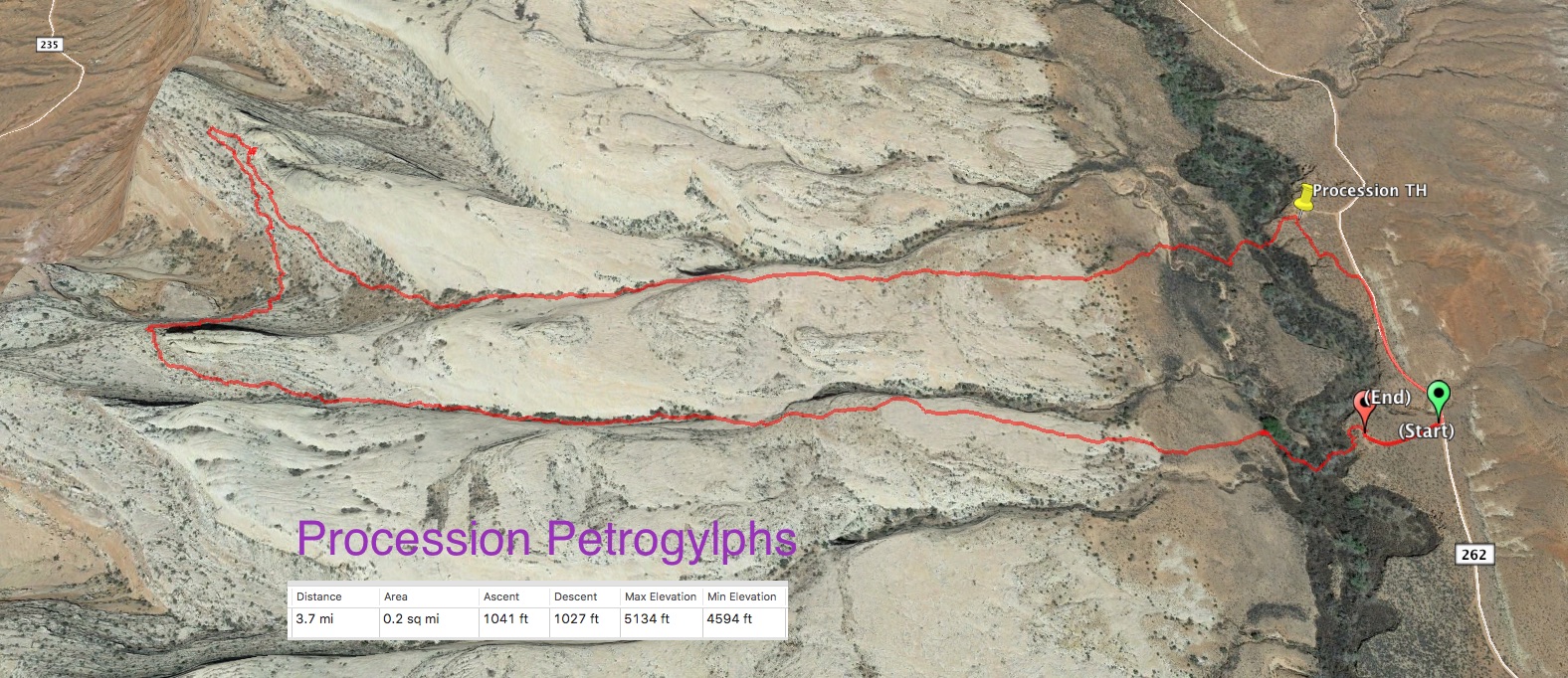
My Gaia GPS tracking had a difficult time keeping an accurate track in the fins, canyons and crevices, but looking at the overview on Google Earth is always a fun way to see the terrain in the proper perspective.

There were a number of places where we passed thru very thin passages which brings out the adolescent excitement of exploring “unknown” passages in the earth.

IMG_1227


IMG_4191

IMG_4213

Utah Hikes

Horseshoe Bend near Page

Horseshoe Bend near Page – click to enlarge

Fall and Spring are the best times to explore our neighboring state’s hiking opportunities. And yes technically Horseshoe Bend, 5 miles from Glen Canyon Dam, is in Arizona, but it IMG_3736was the only photo taken in Arizona this week that didn’t have rainy weather.  Monument Valley was totally in dark wet clouds when we drove thru the Navajo Nation’s Monument Valley Park so that picturesque desert treasure was less that photogenic as you can see on the left of Totem spire.  We never even got out of the truck for that entire loop.

The rest of the week we spent hiking 7 trails in Utah in a semi-circle from Comb Wash to Boulder, Utah. The occasion was a Father/Daughter trip for Mike (my Durango hiking partner) and Stacie with her husband Cary and me along for support.  Cary had a professional interest in this part of the Southwest, since his tour company features guided trips in the area thru Off the Beaten Path tours, so Cary pretty much set the itinerary.

IMG_3732It was great because several of the hikes were not ones that Mike or I had experienced and seeing things like this remote Procession petroglyph panel was pretty special.

NarrowsMike

And visiting the heavily visited trails in Zion National Park, like the Narrows water hike or Angel’s Landing, were places we don’t normally take on.  But hiking 6 miles in water on a cloudy day at 62 degrees lessened the normal throngs down to a trickle of only a hundred or so.

IMG_3756We opted out of traversing the final leg of Angel’s Landing hike, which scales a sandstone fin with chain grab rails, due to heavy downpours and thunderstorms.  Pictured is the easy part of the hike to the middle Unknown

saddle. A “commons” photo from Wikipedia, of the rib is shown below, as it was too wet to bring out a camera and shoot up.

We were satisfied to make it as far as we did although we did see a father with a child-seat backpack coming down from the very top.  His wife must not have been along on this hike.

Good company, good food and good hikes made for a very fast week.

IMG_1057

IMG_3856


Patio Drive-In, Blanding Utah


Hell’s Backbone Grill, Boulder, Utah


Procession PetrogylphsBryce LoopsKodachromeCalf Creek WaterfallBoulder Mail Trail

Eager to go back if you’re interested.

Indian Summer – UL Gear test

Emerald Lake with Turret Peak 13,835 in background - Double click

Emerald Lake with Turret Peak 13,835 in background – Double click

Lucky to get out in the high country one last time this season.  Normally at this time of year there is a early snowfall, cold weather or too many hunters which keeps us from considering a trip up high.  Main impetus for a short Fall hike was to test out a new UL pack (which didn’t arrive in time) and to see how Mike’s knee would hold up (it did well – recent minicus repair).  There had been snow in the high country a week earlier, but warm conditions melted snow on all the south facing slopes and left only 4-6 inches on the north sides.

IMG_3683Hardly a cloud in the sky the first day and none the second. Only saw one young couple at Overlook Point so we got our photo taken.  Ryler is Mike’s lab, carries her food in and Mike’s gear out. Orange vest is because it’s rifle season. Just behind us is the Chicago Basin and it’s mountain range including the 14’er Eolus (farthest right).

EmeraldLakeElevation

Not sure you can pick up on the elevation loss and gains in the left Google Earth photo but we managed 6,000′ in two days.  Most of that descent and ascent was in 4 to 6″ of crusted snow, which was nice and stable.

Ruby LakeThis view of Ruby Lake shows the snow on the North side which outside of the reflected glare off the snow was  quite easy to scale up.  Having hiking poles helps especially giving you at least three points of contact.

The water in Ruby was so clear we could see some very large – 18 to 24″ trout – feeding in the shallows as we approached.

P1010634

Camp was great with a late sun exposure right thru the trees until it sank below the ridgeline.  We expected a cold night so put up plenty of wood for a warming fire which allowed us to stay up until 8:30 almost 9.  Mike’s thermometer read 33° in the morning so we learned the ultra light gear and us passed the test.  Both our packs were below 14 pounds, food and water included.  Base weights were under 10, mine was just a hair over 8 pounds.  Sure makes it easy to go backpacking when you go UL.

WIS Trip Report:

Trip Report: Emerald Lake Loop, October 11-12, 2015 Tom Galbraith & Mike Taylor

Route: TH 3 miles up Henderson Lake Road (081) to Emerald Lake via Overlook Point to Ruby Lake and return

Report: Several hunter camps along Upper Henderson Lake road, didn’t go to Lime Mesa TH thinking there would be numerous vehicles and trailers in parking lot. Started hike from hairpin turn with trail west of Lime Mesa. Interesting to realize that trail is open to mountain bikes and “stickered” brown plastic post only restricts motorized vehicles, and we couldn’t tell when we entered the Wilderness without looking at the map. Boundary appears to be about 1.8 miles up this popular route when it meets the trail from Dollar Lake to Overlook Point. It might be worth considering adding a No Bicycles sticker to the post at the above mentioned Trail head since many people start up from there rather than go all the way to the Lime Mesa Trail Head.

We only talked to two young hikers at Overlook point. No hunters, no rifle shots and no game in our two day hike. The campsite we’d rehab’d the previous year at Ruby Lake looked great, the extra fire rings we’d removed totally gone and grass grown back. Only one plastic water bottle along the trail and a half buried spam can for litter at Emerald Lake. Saw several very large trout in Ruby Lake and only fingerlings in Emerald. No evidence of camping on Emerald Lake point and the upper campsite was in excellent condition. Four to six inches of snow on North slopes down to Ruby Lake.

The previous erosion control measures on the old abandoned road to Overlook Point are working, but new trenching on some steep slopes is occurring. We had to step out of the trail which was eroded deep and narrow 4-5 places in the middle of the uphill section from north Dollar Lake to Overlook Point.

Great days and excellent cloudless weather. Glad we got out.

Finished Via Alpina

We’d read a David Sedaris piece in the New Yorker about his addiction to his FitBit, never imagining it would be something we’d enjoy.  With his humor you never quite know where the humor steps beyond the reality, especially when he was talking about quadrupling that 10,000 step benchmark recommended for daily health.  (Click on the link if you want to enjoy his FitBit exploits). Funny thing is, it isn’t too hard to double or even triple that benchmark goal on a day’s hike, when you’ve got all day, plus a lunch of salami, bread and cheese. 

All the reviews written about the Apple Watch say there isn’t a “killer app” out yet but every geek comments on how they’re getting far more exercise, because like with the FitBit buzz when you hit 10,000 steps, they get a similar feeling when the Watch reaches it’s target. There’s a lot of focus and emphasis these days, besides our not so subtle encouragement to get outside, to increase daily exercise.

At the end of each day, and truth be told often times during the day, we’re eager to read just how many steps we’ve logged.  Our goal hasn’t been to set any step or mileage records, just to finish each day’s hike with enough pleasure, visual memories and energy to do it again the next day. And now we’ve happy to say we’ve hiked the Via Alpina across Switzerland, as well as the Haute Route.

What’s  astonishing is what thirty days’ hiking amounts to in steps.  Here’s Stanna’s FitBit log for the last month


Younger Next Year.  Trouble is we probably ate all those calories calculated by the algorithm as well. Especially when we celebrated with a large pot of fondue and mountain of meraguine. 


Back on the Via Alpina

  
Last year we hiked the Via Alpina from Sargans to Adelboden about 225 miles before we had to return home to Durango.  This year we’re finishing the Swiss portion of the trail, four more days to Lake Geneva.

It feels good to be “thru hiking” again, going from one town to another, always over a pass, which gives you not only grand vistas into and from the next valley, but a sense to accomplishment when you see that last pass way off in the distance.

  
The elevations are a bit lower than earlier in this trip but the daily ascent and descent are just as dramatic. We’ve been averaging about 12 miles a day, when you count getting around town before and after each day’s hike. It’s real interesting to compare all the digital “steps” devices we have (iPhone Health apps and Stanna’s FitBit).  Stanna’s FitBit and my Health app seem to agree most of the time, and to give you an idea they are often both a couple thousand over 30,000 a day when we get in 6 hours on the trail.

  
The last several nights we’ve been staying in very small (5 to 7 room) hotels where we are the sole guests. We like these places better than the larger hotels primarily because of their character and because they’ve managed to remodel older structures into very comfortable accommodations.  This also forces us to search for an evening meal, rather than the half-pension meal provided by the hotel (always very good to excellent) and we’ve lucked out each time finding wonderful meals even though they aren’t four-course.

  
So far we’ve only hiked two days with less than two hours each of rain. It’s been unusually cool and often cloudy, however this has made for very pleasant walking and hardly detracts from the scenery.  Only two more days to Lake Geneva and then we will be finished with the hiking portion of the trip.  Knees, ankles, shoulders and waists are holding up well, despite the abuse. Sure wish we could share the experience “live” with you.

We’ll spend the 17th in Zermatt again for our requisite fondue and meringue  binge.

Swiss National Park

 Unlike the U.S., Switzerland only has one National Park, however it’s easier to understand because it has about a sixth of Colorado’s land mass. (Population is ~8 million to Colorado’s ~5 million). Just think of Estes’ Rocky Mountain National Park as a sole comparison to Switzerland. Rocky Mountain National Park is six times the Swiss park.

  
Established in 1909 and added on to several times it serves as a preserve for a number of animals that had earlier been hunted to extinction. Somewhat like our Wilderness areas they prohibit any human changes to the region and more prohibitively restrict all access to very few specific trails (leaving the trail is verboten). They even have designated rest stops, where yellow topped posts cordon off a half-football field for lunch stops, prolonged resting and viewing wildlife.

  
It’s not quite like Estes Park where herds of elk hang out in meadows, but it is possible to view Ibex and Chamois in their natural settings. We got the feeling it was more like their home and we were on parade up and down those specific trails.

  
Five days was our schedule in the park with one loop, one two-day trek with a stop at the only hut in the entire National Park, another single day loop and then an exit over and out of the park thru a Middle Ages mining district. 

  Their park is quite popular and this is where we’ve seen the most people hiking the same trails as us. One remarkable thing we learned was that their are very few English speaking hikers and even fewer Americans visiting the park. 

  All signage is in three languages and none of them are English; if there is a fourth it’s Romansch.  Fortunately my German has served us well.

Bernina Express

  
Hopefully you’re not viewing the above map on your mobile phone because it’s worthwhile expanding this photo and looking at the beautiful depiction of the eastern Switzerland’s mountains. We had a couple of days of inclement weather and took advantage of them by visiting a glacier up close and then the following day taking a ride on the Bernina express route from Pontresina over Bernina Pass into Italy.

This map by the way, shows almost everywhere that we’ve been for the first two weeks of our trip here in Switzerland. We stayed in Maloja in the top right-hand corner for four nights doing day hikes out of that region and then moved to Pontresina in the center of the map and did day hikes out of there, as well as the glacier and the train trip to Italy. Now we’re down in the lower left-hand corner and the Swiss national Park.

  
The featured Highpoint in this area is being able to see the 4049m peak called Piz Bernina. And one of the many advantages of staying the Pontresina hotels is being given an Engadiner transportation pass that allows you to take the trains, buses and gondolas in the entire region. We had planned to take an easy hiking day by visiting the Morteratsch Glacier from the Diavolezza gondola. There are several short hikes up on top with views of the several other glaciers, however when we made it through the low hanging clouds to arrive at Diavolezza we found 4 to 6 inches of fresh snow on all the trails we planned to hike so we limited ourselves to very short excursions and lots of photo opportunities. We got our daily mileage in by hiking the valley all the way back to Pontresina rather than taking the train.

  
It’s here we saw the long white pillows shown in earlier post where we asked you to guess what they might be. I guessed that they were covering 6 feet of snow so that they would have an early start on the ski season but in fact are preserving the glacier, covering two to three meters of the glacier.

  
The Bernina Express is just one leg of a private railroad system the runs throughout this eastern portion of Switzerland’smountains. This particular route made me think of the comparison between the Durango Silverton narrow gauge as it passes through a similar distance of wilderness in the San Juan Mountains. This route is not through wilderness as it passes through a number of small villages and even towns but it does go through some spectacular scenery and goes over a 2900 m pass, with views of all those peaks and glaciers not to mention precipitous views of valleys. This route has one remarkable featuring where it turns underneath itself as shown above in the photo. We ate our salami, bread and cheese on a park bench in Italy and turned around and came back on the same route and I’ll say it was far less tiring then the round trip on the Durango Silverton narrow gauge.

Guesses?

We saw one of these going over the Surlej Pass and then several up at Diavolezza cable car station near Morteratsch Glacier today.  My guess was close, but still not quite right.  A local Swiss set me straight.

Give it your best guess.  These tarps are at about 10,000′ adjacent to ski areas.