Attractive Nuisance Removed

P1400553The world’s an ever-so slightly better place now because our WIS crew removed an attractive nuisance from the Needleton Trailhead at the Silverton Narrowguage Railroad stop.

This outhouse was probably installed in the 50’s when Needleton town site with it’s few remaining cabins was less of a popular train stop than it is now with almost 10,000 backpackers disembarking at this remote trailhead.

IMG_8002The Weminuche Wilderness area wasn’t designated until 1975 an the Needleton town site is still an “in holding” within the 488,210 acre Wilderness, meaning it’s still privately owned.  Of course the Silverton Narrowguage has it’s right-of-way thru the wilderness as well it’s possible to breech the Wilderness restrictions of “Only primitive forms of travel – foot travel and stock animals – are allowed in Wilderness. This includes motor vehicles, bicycles, wagons, hang gliders, carts and any type of motorized equipment, including chainsaws”.  So the wheelbarrow in the photo was legal just on that tiny parcel at the outhouse and train stop. We brought all our tools in the narrow-gauge train boxcar.
IMG_7998

Our plan was to de-construct the outhouse in order to preserve the barnwood exterior and possible sell it to someone to benefit the San Juan Mountain Association, however once we took a few boards off we were more certain of it’s provenance and little value.  Nevertheless, we still had to pack out the entire structure so we kept the lumber in as much original state as possible.  Tipping it over, proved expeditious to it’s disassembly.

P1400556P1400562It only took 50 minutes for us to have it apart and another 45 minutes to pull all the nails.  After we broke up the concrete base we burned the shingles and scrap wood in the 4 foot iron base. Then we filled the holes and adjacent depressions with the broken up concrete and numerous wheelbarrows of rock, before we set to “naturalizing” the site.

IMG_8004This process took us five times the amount of work, because we had to find a source of easily transportable dirt, not to mention rocks, plants, duff and gravel to give the mound a unobtrusive natural look.

We camped up river overnight and came back the next day to finish off the project and ended up removing three large fire rings and naturalizing them at the same time.

P1400628

IMG_8002If you’ve read this far, it’s worth showing at couple more photos since this started out with removing 4 large trash bags of trash that had been thrown down the seat.  And what the load all bundled and bagged up looked like for the baggage car home. It was fitting that we took on this project during the 50th anniversary of the Wilderness Act.IMG_8006


The crew was pretty satisfied with the results.

P1400616


Pear Lake Loop

IMG_7327We snuck in one more quick trip into the Weminuche Wilderness this last three days.   I wanted to get back to a spot I’d visited several years ago, when I first returned to backpacking and ultralight gear.  Mountain View Crest Overlook is just south of the Weminuche’s 14’ers and the Chicago Basin and offers an outstanding view directly across from that range at almost 13,000’.

PearThere are a number of lakes in the immediate area and we visited at least four of them plus a number of unnamed ponds.  Our destination was Pear Lake where we set up camp the first day and later dropped further down in the afternoon to visit Webb Lake and it’s view up Needle Creek to Chicago Basin proper.

Forecast was “mostly sunny” in Durango, but it never quite cleared at our elevation and remained cool such that I never separated the zip-off portion of my pants, although the first night never dropped below 41°.

SANY0049Since this loop was short in comparison to many of our adventures ,we had plenty of time for fishing (I actually bought a license: $1 for the year includes Search and Rescue rider, but not transport), and exploring.  In addition to looking for new trails and routes we spent considerable time rehabilitating campsite fire-rings.  Often times there are several rings in one campsite, or in totally inappropriate spots like the SANY0035one at Ruby Lake where there was no firewood and was technically in a prohibited watershed.  After disposing of 18 one-gallon bags of ash and charcoal we restored the pit with a similar number of bags of fresh dirt (thanks to prairie dog mounds) and a few native plants.  And it allowed for a third tent site.


P1390594MikeRylerRubyMike had great luck fly fishing, and no luck teaching me to “clock to 11PM and don’t bend your wrist”.  He caught and released 12 fish before me and one after, while I caught only reeds and weeds.

Our hiking partner and ultralight guru, Will Rietveld, Southwest Ultralight Backpacking, was reviewing three new lightweight pack prototypes, so we switched off each day, gave unhelpful comments, andSANY0012SANY0054 modeled for his analyses.  Fun to see what’s in the pipeline in the way of packs and even more fun to hear and share tips and tricks on cutting weight down and making gear serve two or more purposes.  We couldn’t help suggesting that Will should show how he tests all the packs on a trip like this by trying them all on at once.


Next day was even more leisurely, visiting other lakes, fishing, checking campsites and exploring the area.  We only managed 16+ miles but climbed and descended 6,400’ in this tight mountainous region.  If the weather were less cloudy our photos would be worthy of publishing as the views were spectacular.

P1390605

Williams Creek Loop


WilliamsCreekLoopMike Taylor and I planned a three-day backpacking trip in the Weminuche north of Pagosa Springs, an area that neither of us had hiked before. We watched the weather and delayed one day to get the best window for our trip, which turned out perfect even though the morning we left the National Weather Service predicted late afternoon thunderstorms for only our section of the San Juan Mountains. The clouds did form but not a drop of rain until late the second night when we were well out of the high country.


IMG_7214Just reaching the Williams Creek Trailhead was a pleasant surprise because the rolling hills of combined National Forest and remote ranch lands north of Pagosa are a delight to drive through. This is definitely horse country as evidenced by the “Campers with Horses Only” campground designation at our trailhead. (There are numerous other unrestricted campgrounds spread around the area in close proximity).


SANY0001


Mike and I have hiked a number of trails this summer as WIS volunteers and we’ve experienced, and come to expect, recording a high number of downed trees and water erosion along the trails, but we were pleasantly surprised to find not a one for the first 9 miles.  We only saw 2 groups of backpackers the first day (one couple from Ouray with a “borrowed” llama who knew mutual friends).


IMG_7197


We camped right at the edge of tree line due to the weather report but could easily have camped, with ample water available from several small lakes, just below the Continental Divide at 12,200’.  Mike enjoyed trying his new Hexamid Duplex tent with Ryler his lab, and it was fun to see the two generations of zPacks tents set-up side-by-side.  His has new features I’m envious of: double doors, higher roofline, a sewn-in Cuban fiber floor and generous vestibules on both sides. (Don Ahlert had the same tent on the Great Divide.)


SANY0009


The views on this crystal-clear deep-blue-sky morning along the Continental Divide Trail portion of the Loop were spectacular: looking south all the way to New Mexico and north directly into the Weminuche’s isolated Squaw Valley and to Colorado’s most remote 14ers, Sunlight, Windom, and Eolus as well as the Grenadier’s.

IMG_7230We’d planned two nights in the high country, but found on descending the Cimarrona Creek Trail there were no flat spots for two tents, let alone proximity to fresh water, so we soldiered on and on and on, all the way to the valley below, 16 miles before we could camp.  Neither of us believed there wasn’t a spot “just around the bend”.  The nine-mile 4,100’+ climb the day before was plenty, and this turn of events on the never-ending downhill gave us little respite except for one photo op under an unusual (for the San Juan’s) conglomerate arch (photo above).

SANY0006I had the worst cramp ever after dinner the first night when the temperatures cooled down.  Just a minor move while reclined on my mat brought on a massive inner right thigh cramp that levitated me up off the ground in pain.  After two minutes of hollering like a wimp, I remembered that I needed to do some stretching after that 4,100′ climb.  Mike caught me in the downward dog, which will please my yoga teacher when she see this photo.

IMG_7217

Mike felt like this was prime moose country and validated the thought when he came upon a juvenile moose track at the top of Squaw Valley.  Moose were transplanted into Creede nearby a number of years back and it’s unusual to see one in the Weminuche.  We did see a number of deer and some young elk and only one bear track.

Ice Lake Basin

IMG_7118Getting back in the high country was the main reason to leave the Great Divide trail at Steamboat and this week’s solo backpacking trip to the Ice Lake Basin was reinforcement.  There were definitely beautiful views in the northern Rockies but we’ve got such great country right in our backyard.  Ice Lake(s) is known as one of the premier hikes in the Southwest and if you catch it when the wildflowers are blooming it’s unbeatable.  

IMG_7126

My trip was a couple weeks past prime, since I was still on the GD ride I missed the height of the season, but I also missed 10 days of heavy monsoon rains in the San Juans.  The IMG_7114wildflowers were a bit storm worn, all the same they provided quite a photogenic sight for those of us “late” to the blossoming.  There weren’t as many Columbines (Colorado’s state flower) in the basin as we’re used to seeing, probably because of the very late winter in the San Juan mountains, however when you found a bunch they certainly gave you pause and a smile.

IMG_7124Long shadow photo op’s still catch my eye, and early morn at 12,250′ makes for a nice contrast.  First light at Ice Lake is a wonderful time just to watch the sunlight slide slowly down the mountains and across the high green meadows.  And check out that true blue sky.

IMG_7141

Exploring the highest points of the upper basin seemed to be in order and I wasn’t disappointed when I discovered a long-abandoned mining operation just below the passes at the foot of Vermillion and Fuller peaks.  The detritus from the past mining operation was fascinating and told of living above 13,000′ digging for gold with hand-cranked ore buckets and hob-nailed shoes.  The midden pile of rusting cans could fill a dump truck and the purple and light-green broken glass bottles reminded me that they lived there for quite some time.  A crushed brass tub and dynamite fuse cord strung across the scree slope added to the discovery only those who venture this high get to enjoy.

IMG_7151

One wishes everyone could see this beauty, on the other hand if everyone came this high there would be nothing of the relics left to enjoy.  As it was I’d seen a hand-carved sign broken up for firewood much lower down.  Wish I could have read what it originally said.


When I came down from my high morning traverse of the basin, throngs of hikers popped over the ridge below to view the lake I’d had all to myself.  The weather brought an unusual number of hikers, Stanna and her Wednesday women’s group as well.  She had planned her venture weeks before and the weather worked out perfectly for them.  My Spot Locator told her where I was camped and they almost got to the tent before I had time to pack it up.

IMG_7158

At this point, I felt like an intruder to their high altitude picnic, so I ventured off with my backpack to a higher lake to the northeast of this basin.  As a WIS volunteer I’m supposed to be familiar with the territory and I’d never gone over this adjacent ridge, so I supplemented my local knowledge by visiting nearby Island Lake. Luckily, there was someone else there to take my selfie.  Come visit us and see for yourselves; after all, “how many summers do you have left?”

IMG_7165

Back in the San Juans

IMG_7071
Finally got back into the high country again, this time without any planing or forethought, just accepted an opportunity to join fellow UL friend, his daughter and granddaughter to an early morning start on one of Durango’s most famous hikes, peak climbs and landmarks.  The wildflowers took a beating over the last week and weren’t still in their prime, nevertheless offered splendid colors and contrast to the sometimes bleak roads I’d recently traveled.

PassTrailTrack

Only 30 miles from Durango, just north of our Purgatory Ski Area, at Coal Bank Pass you leave the summit parking lot and wander uphill thru some old growth trees and verdant undercover to the high meadows below the just-under-13,000′ Engineer IMG_7095Mountain.  For those not adverse to “a bit of exposure” the trail continues right on up to the peak for a total of 2,800′ of elevation gain.  It’s always best to be off the top before lunch in the San Juan’s and we were well within those guidelines with a total “moving time” just over 3 hours.

In case you might be anxious about the climbing part of this hike, I should have photographed the 5-year-old who summited shortly after us (admittedly his mother was not along).

Besides having the Spot Locator on, I enjoy tracking the hikes with my GaiaGPS iPhone Ap.  It’ll give me all the stats save calorie count.  At the end of the hike I can export the track to my computer and import the track into a variety of applications like Google Earth or my new favorite TOPO a National Geographic app (shown above).

IMG_7070This hike also qualified as a WIS hike since I wore my Forest Service Volunteer shirt, picked up trash, blocked off switch-back short-cuts, answered hiker questions and took note of downed trees. Our reports go to the FS trail crews who come out later and remove downed trees and repair trails.


As if hiking for the beauty, pleasure IMG_7087and exercise is not a goal in itself, the WIS (Wilderness Information Specialist) aspect gives these hikes an additional purpose and the benefit of community service, which makes getting out all that more significant and pushes me out the door more often.


Thru Hikers

As you might imagine the Great Divide route along the Continental Divide crosses tracks a number of times with the Continental Divide Trail (CDT), a cross-continent trail for hikers.  The CDT is one of the jewels in the Triple Crown of American hikes, the others being the Appalachian Trail (AT) and the Pacific Crest Trail (PCT).  I saw and talked to probably 12 or more of the hikers, always in groups of two or three, trying to glean whatever I could about their ultralight gear.

The one question I always try to remember to ask is, “What would you do different. Or what would you change if you could?”  This far along, all that I talked to had started at the Mexican border and had already “dialed-in” their gear, so I generally got comments like, “the weather” or “nothing.”

IMG_7067One solo hiker was zipping along with his head net on. After stopping and talking to him for several minutes along the road, I asked him about his net, which evidently was so comfortable that he hadn’t noticed it was still on.  He quickly pulled it off, embarrassed, saying he didn’t know he was wearing it from early morning.

Later I asked another group of four about head nets and one hiker quickly whipped his out saying it was the best one available, Sea to Summit, and that I should try it on.  It actually has underarm shock cords that keeps it down and away from your neck.  I’ll definitely be looking into this new piece of gear for backpacking.

Other info gathered from the troops of thru hikers: One preferred a canister stove, a cheap 4-oz knock-off of a MSR with the smallest fuel can, he only ever carries one canister and when it’s out, he eats “cold” until the next resupply.  One guy carries his alcohol in a squeezable Platypus water bag, so volume decreases with fuel level.  Another guy absolutely loves his Z-pack chest bag (another item I’ll be looking into).

Most hikers seems to be in the 12-pound base-weight range and most had a tarp-tent.  All but one was in trail-runner hiking shoes, everyone had poles and two I saw coming down the road with identical Go-Lite Chrome Dome umbrellas deployed above their heads like Asian ladies in the afternoon sun.  Water filtering was with Sawyer minis or Aqua Mira, no one mentioned SteriPens.

Most surprising was a couple of guys, the ones with the Chrome Domes, said when I mentioned Z-Packs, “Z-Packs gear doesn’t hold up.  Not suitable for thru hiking.” When I protested that I love my Z-Packs gear, they remonstrated adamantly, “it may be great for bike packing but it’ll never hold up to a thru hike.”  Strange, I’ll be looking into this further.

Best of all, every one of the thru hikers seemed jovial and eager to talk about their gear and the six-month journey.

New Addition to the Clan

IMG_6779A lot of schedules and routines got jjiggered over the last couple weeks with the pre-mature birth of Inari, the new daughter of our nephew Christopher and his girlfriend Aidan.  Long story, but short version was that Aidan and my sister Donna were air-flighted to Denver several weeks ago, where mother and unborn Inari were ensconced in a high-risk unit in Denver’s premier preemie hospital.  Baby was born at 36 weeks and she arrived at 4 pound 2 ounces in good health.  Adding to the kerfluffle was they closed on a new IMG_6778Durango house (via FEDEX) while in Denver, and all the family and friends moved them into it in their absence.  Stanna had to rush her contribution off the loom in time for their return to Durango and the new crib. The super soft blanket was fashioned in green because she (and the parents) had no idea what color blanket would be appropriate.

IMG_6774

Hke and bikeI finally managed to slip away for a couple of single-day jaunts – a shake down bike tour and a trail hike.  The Shake-Down was a bike packing trip to check out all my gear for the Great Divide ride, and it proved worthwhile because I had a number of bike failures that I’d rather take care of locally than 1,000 miles away.  First the seat came loose from the seat post after about 20 uphill miles and then the bottom bracket started to make ball bearing grinding sounds as I reached the summit after the 4,500′ climb.  Thankfully there was still plenty IMG_6775of light and one Subaru high up on the pass, so I hitched home rather than continue with the overnight trip. It wasn’t easy climbing the last 2 miles out of the saddle, so I’m going to change out the seat post before I go out again.  (The bolt wouldn’t tighten enough and I didn’t want to strip it – I’ve already experienced a stripped bolt this year).  My nephew Christopher, the new father, will change out the bearings in the bottom bracket as soon as he settles into the new house.

And instead of waiting on the new house stoop with all the family for the baby’s arrival, I snuck away on a day hike with Kurt.  We cleaned trail 5 miles up Burnt Timber Creek for the Forest Service under the WIS program I’ve joined.

IMG_6768Saving the best for last, I got to set-up the latest Zpacks Hexamid Duplex tent I ordered for my riding partner on the Great Divide.  I’ll have to have one for next season as it’s only 1 ounce more than my current Hexamid and has lots more features I’m impressed with. I especially like the fact that you don’t need to place the poles inside the screen, the sewn-in bathtub floor, and the over-lapping double doors, plus the extra head room for the 2nd side.  For the sailors out there, this is all Cuban Fiber sail cloth fabric (total of 19 oz for two people) .


Breaking the Fun Barrier

IMG_6580John Wesley Powell reportedly used this iron-prowed skiff and ones like it on his 1869 exploration of the Green River in Utah. We travelled in far better skiffs, in fact I was the crew in a restored Grand Canyon dory owned by a Durango friend, John Lawson.  This dory was recognized by other rafters on the same river and John was told that there are photos of the Niagara running the Grand in a movie making the Art House film circuit, called DamNation.  This was my first time in a dory and I was lucky enough to row her and take her down a couple class 3 rapids.  The ride is much different than in a conventional raft because it only has a four-foot wide “wetted surface”.Niagara

DCIM100GOPRO
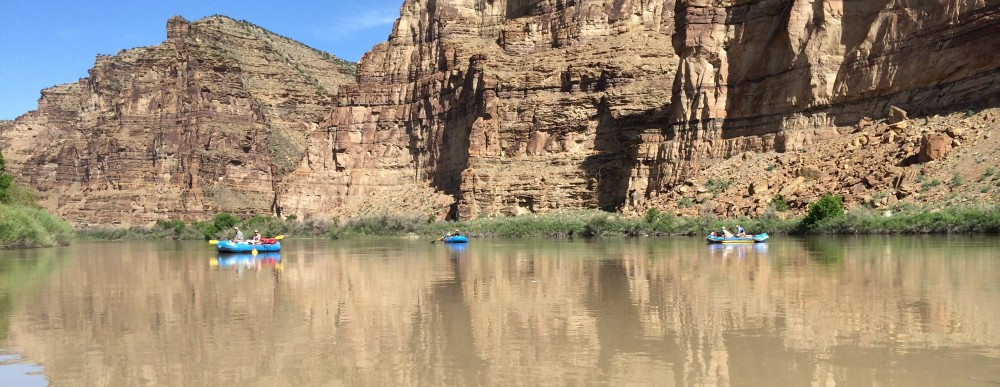
Great trip, 11 people on 6 boats for six days.  Actually, the best trip I’ve ever had down the Green River thru Desolation & Gray Canyons because the heat and bugs weren’t an issue this time of year.  Forecast was for perfect warm weather, but high winds and night rains struck us several afternoons during our dinner gatherings.  Fortunately all the boaters were experienced and well-enough equipped to handle DCIM100GOPROadversities both on and off the river.  The pictured “para-wing” tarp covers the kitchen and most the galley.  Only one night did we have to have five people hold down the tarp as 35 MPH and higher winds whipped down the beach just after dinner.  As you can see in these photos, most of the camps were on sandy beaches which makes for easy camping.

For those who’ve never done multi-day river trips with a private group, the meals are divided up by boat and on this trip each boat was responsible for one dinner and one breakfast (lunches are individual since they don’t require a community kitchen).  It’s always a treat to see and eat meals the other boater provide for the group. Our “directives” were not to make very fancy or elaborate dishes so our crew made grilled pork chops, vegetable shiskabobs and mashed potatoes.  Cheese cake with berries for dessert. (We forgot to pull out the Cool Whip for topping.)

IMG_6591IMG_6588Lunches weren’t too shabby either.

Fun time on the river and evidently the same storm came thru Durango and shortened the Memorial Day traditional Iron Horse Classic to only 25 miles and none of the passes.  Glad I’d opted for the desert and hiking this year rather than training for the mountain passes.

And just because it doesn’t warrant a full blog on it’s own, I made a quick 2-day mountain backpacking trip just out of Durango IMG_6595behind the Purgatory Ski area the day after getting off the river.  We started high behind the ski area and hiked down the Little Elk Creek trail to the Hermosa Creek drainage, 13 IMG_6594miles, and then back up another trail further south called Dutch Creek trail.  It was fun once again being the first footprints on the trail after the winter snows melted.

We’d hoped to see lots of animals this early in the season.  Lot’s of fresh tracks and scat, but we only saw a young black bear scooting away at a speed I’d never thought possible.  When I asked about their mobility my hiking partner told me they can easily do 30 MPH and uphill at that.  Creeks were so high on the return up Dutch Creek that we had to ford with our shoes off three times.  Amazing how easy it is to get in a first-class backpacking trip in just two days only 30 minutes from home.

Pine River Trail

IMG_6418 - Version 2Several friends and I were itching to go backpacking once again. Our backpacking trip in the desert several weeks ago, was probably the last one possible until the Fall because the daytime temps make hiking uncomfortable.  We finally got to backpack into the (lower-part of the) High Country wilderness around Durango, by going up the “Horse Highway” as one friend at Rotary called it. About 32 miles ENE from Durango are the Vallecito thresholds to the Weminuche Wilderness.  I’ve hiked several trails directly north of the Vallecito Lake drainage into the Weminuche, but not the more Easterly drainage of the Pine River. Many Trail Head parking lots have hitching posts for horses in our area, but this TH had rails for 25 or 30 head. It must be a horse highway because of it’s gentle rise along the Pine River for over 20 miles.  IMG_6434Fortunately for us, we were the first to travel more than the 3 miles up to the Weminuche boarder sign and get the first look on to the trails this season.  Horseback riders are probably aware that it’s not a good idea to venture out on these freshly thawed trails because of the all the deadfall from even our mild winter makes the going tough. We’d come across so many downed trees that we couldn’t clear, it would be very discouraging for anyone on horse IMG_6553back.  One family of beaver were very active recently leaving more than 20 large sized trees blanketing the trail.

Most of you don’t know, but I’ve joined a group of volunteers known as Wilderness Information Specialists (WIS) and this was just the type of hike where we can be helpful, in that we recorded the quantity and size of the downed trees that a trail crew would have to come and remediate.

IMG_6573By enlisting as a WIS volunteer I’m forcing myself into spending more time in the backcountry that I have habitually said, “I’ll enjoy the area close to Durango when I get grey”. Well, what’s left on top is certainly grey, and as the byline says, “How many summers do you have left”.  Now is the time to get out there.

Having converted to an evangelist ultralight backpacker makes the endeavor all that more enjoyable.  Four of us, all similarly out-fitted, pushed the season door open and tramped IMG_6447almost 20 miles up this horse highway until the snow line only offered “post holing” for passage.  Over the two nights and three days we camped low (8,880′) and hiked high (10,000′) so that the night time low temps wouldn’t be more than our light weight gear and packs could handle.  As it was the lows hit 23° F and we all slept in every stitch we IMG_6468brought inside our sleeping bags (No one got cold).  We did allow ourselves a campfire in one to the established campsites both nights, so that kept the chill off while we waited to bed down. It was really fun to see the foliage pressing itself out of the ground like the skunk cabbage (false hellebore) shown below.  This plant will grow to be 4 to 6′ tall by Fall.IMG_6526


And even though we all had base weights in the 10-12 # range we still had room for a birthday cake, albeit with only one candle.  Mike Taylor celebrated a “surprise” 71st birthday midway thru the hike.  I should also probably mention that the average age of the crew was 69 years old.

2014-05-15 18.28.25A good time was had by all. And ice cream was the first stop on the way home.


Sedona

100_5148We’ve written not as much about Stanna’s adventures primarily because there aren’t as many photos to show off her exploits.  Just now she’s editing those from the India/Bhutan/Nepal trip and perhaps we’ll feature that trip retrospectively.  Nevertheless I intercepted a couple photos from her Sedona hike with 8 of her Wednesday Hiking Ladies group, just last week.  Several of the same group made the Nepal trip this year and another, Debi, led the Switzerland trip several years ago.  Reportedly there are more than 20 women on the emailing list and typically 6 to 12 can show up any given Wednesday.  They’ve been taking overnight excursions to regional trailheads in addition to the local day hikes.

100_5141The trip to Sedona, Arizona (6+ hours from Durango – south of Flagstaff) is the latest multi-day excursion where they hiked several trails over the three days they were there.  Stanna has hosted several overnights up in Silverton in the past and they’ve gone to Pagosa and Moab as well.  The Ladies share trip leader responsibilities over the year and Stanna has led quite a number hikes herself.

Box CanyonHikes change each week so there is variety in distance, terrain, and effort: something for everyone, but generally they are 3-4 hours, and cover 4 to 6 miles average each time.  On the calendar for this summer is a Hut hike over in Dolores County and maybe a backpacking trip into Chicago Basin in the Weminuche Wilderness, besides the weekly Wednesday hikes.

Slickhorn

IMG_6293Spring and Fall are the only rational times to go backpacking in the Southwest Desert and I was lucky enough to get invited on a four-day adventure thru the Slickhorn region of Cedar Mesa in Southern Utah the first week back from Thailand.  There are now at least four other Ultra-light backpacking enthusiasts in Durango and we all ventured 3 hours southwest to hike a route chosen by the mentor of many who prefer to pack ultra-light, Will Rietveld. (He’s written about and reviewed Ultra Light gear for quite a number of years and is a native Durangoan – link.)  Actually everyone on this trip except me  has hiked all over this southwestern wonderland, but only Will had done this particular loop before. Last year I’d hiked and blogged about trails north and northeast of Unknown-1this region, so it was good to discover another patch of this BLM-protected land where hundreds of Ancestral Puebloan ruins exist in a desert backcountry setting.  You’d think we’d get tired of seeing and visiting ruins because we live so close to Mesa Verde National Park, but when you find these relics and ruins of ancient time along a trail without a soul around, it always produces awe and wonder.  These folks, the Ancestral Puebloans, spent about 1,200 years with estimates of as many as 40,000 people this desert backyard of ours, WoodenKivaand it’s a never-ending quandary thinking about how they lived, farmed and especially wintered in this high desert region.  Not much remains and when you come across their art, their houses and their shards or a tiny corn cob, it’s pretty special. 

I’ve seen and gone inside a fair number of Kivas (ancient underground structures thought to be ceremonial or religious in nature) but generally not often in remote locations where there is only a placard rather than a ranger telling you to respect the ruins.  In our 4-day 41 mile trek we probably visited at least 3 or more sites a day, which besides providing cultural InfoBinderconsciousness was always a welcome break out of the sun and heat.  At the “Perfect Kiva” they even had an information binder stowed in an ammo box if you wanted to know more about that particular site, it’s discovery (as late as 1976) and the environs. It’s was amazing that we could still go down inside the Perfect Kiva and hang out as long as we wanted.

IMG_6358IMG_6362Not sure how many readers are familiar with the Ancient Puebloan concept of the Sipapu, so I’ll let you know it “symbolizes the portal through which their ancient ancestors first emerged to enter the present world” Wikipedia. All these Kivas had distinct Sipapus as well as well-used niches, chimneys and the meditative tranquility of a very scared place.

IMG_6364

Of course, just hiking thru, around and over sandstone canyons is worth the effort.  We averaged 10 miles a day and not much of the route was on what you might call a conventional trail. This area is often visited, but requires lot’s of route finding thru the boulders, stream-beds, slick rock  and slides.

traverseboxcanyonAnother benefit of hiking with these UL guys is that we all can learn some new or alternate tip or trick and I was able to tweak my gear shortly after getting home.  Can’t wait to get back out on the trail again soon.

BTW on this hike my base weight was just under 9 pounds, plus food and water which decreases each day.  Sure beats the 40-pound days of the past.


Five Fingers

IMG_4511

Not enough time to blog about last trip. Only home for 24 hours. I’ll catch up soon.

P1320774
Fall is regarded as the best time to visit the Southwestern desert and we hit it just right. Squeezing in a five day trip to Utah’s Canyons National Park was the perfect way to finish a summer hiking season. Our route was different if you watched out Spot Locator track since we base camped 10 miles into a series of dead-end canyons and tried, unsuccessfully, to connect between them each day.

IMG_4472
Fortunately, Will Rietveld did a lot of Google Earth research before the trip and set out a goal of trying to connect up a number of the box canyon fingers to make a loop route for future hikes. Zero for four was our success in the multi-day assault on the various fingered canyons. At the terminus of each valley we bush-whacked our way up to the sandstone and scaled the clean knobs and various cracks, only to find we need contour or traverse a bowl and go further up.
Five Fingers
The rewards of discovering windows thru the rock, caves and tunnels, arches and grottos far out weighed the chagrin of not managing a pass between to fingers. Not to mention the colorful sandstone layers contrasted by the clear blue desert skies.

IMG_4560
Making tracks in the pristine sandy washes didn’t hurt the feeling of treading on forgotten territory. Forgotten because in several of the canyons there is still panels of artwork from 1000-3,000 years ago, as well as remnants of grouted walls and small watch towers that proved people roamed this region long before us.

IMG_4532

IMG_4524