 Boy were we pleased to hear Dragonfly’s land dinghy was headed our way Friday afternoon. They thankfully and finally finished the remodel and sale of a house in Indy and left directly from the closing table to California, navigating thru Durango for a short respite along the way. Since Al always transits with his Trek were were able to get in a ride while he’s here. The afternoon monsoons held back the entire time and we lounged in the condo cockpit over the
  Animas River, took in a Music in the Mountains concert on the grass of our local ski area, managed a spin class at the local rec center and had lots of great meals, conversations and enjoyed catching up. And Al and Jill even humored us with a hike and a little bit of bushwacking above 10,000 feet. Incidentally they did super for folks who spend most their time on the sea. We sure like it when folks come to Durango to visit, hope to see you soon. Stanna serves up some really good Thai food these days.
 Dragonfly’s charter website is at http://www.saildragonfly.org/ and their personal Blog is at http://saildragonfly.wordpress.com/ and of course they use Facebook at http://www.facebook.com/al.wigginton
Monthly Archives: July 2012
Air Park Fire
 We’ve got another fire close to Durango. Started out at 10 acres and by dinner time it was 500 acres. Fortunately it’s south of town west of our private air park and south of the new Nighthorse Lake. But a large housing area is on notice for evacuation. The Durango Herald has the hourly updates online. http://durangoherald.com
Update: Fire appears to be under control with the help of several days of thunderstorms not to mention air tankers, helicopters fire suppression and boots on the ground.
End of the Ride

Last pass was Carnero at 10,166′
Knowing that I wasn’t going to go past Del Norte made the last day almost anti-climactic except for the climb to Carnero Pass. Just south of Del Norte is one of the tougher climbs up Indiana Pass to 11,910′, but I’ll have to do that one another trip. The entire Great Divide route is 2,900 miles from Banff, Canada to Antelope Wells, Mexico. I’d done much of the Colorado segment, somewhere close to 500 miles in 5 days and was happy to know I can tackle this kind of adventure.

Cannondale Super V tricked out for bike packing. Full camping, clothing and food on board. Water and electronics in a small backpack
My generously-donated 90’s Cannondale Super-V, is in need of some serious help. The rear shock is almost spent, the bottom bracket needs an overhaul, and the brakes won’t adjust far enough from the rims that they don’t occasionally drag. It has served me well for a number of years on many bike-packing and single track adventures, but now I need to investigate alternative saddles and figure out what the loud creaking is when climbing under torque. A new(er) mountain bike could be in my future.
Here’s the Spot track if you didn’t get to follow along. The URL for my Spot device I carry on all my solo hikes and rides is http://share.findmespot.com/shared/faces/viewspots.jsp?glId=06sdbN7n5jDTx6JLO0a2IU4QYlG5sK3Hn 
Three passes to go
I’d heard that Al in Indy was really fascinated watching my Spot track on the web, probably much the same way we enjoy watching his track across the ocean in Dragonfly. So as I climbed the next 3 passes I kept wondering if Al was fixated on his computer hitting Refresh to see how I was doing. I hadn’t published the site beforehand because I wasn’t so sure I would complete the journey, but Stanna let the word out as people checked in and learned I was quixotically challenging myself.
 With a couch to sleep on and a warm shower it was easy to manage an early start, hoping but not planning on summiting two of the last three passes on my limited Great Divide route. I knew I’d have to camp, it was just a matter of how far and when. The butt butter got me much farther than I’d imagined and the only thing stopping me from the second pass was the terrific blasts of thunder and lightning not to mention dark black skies threatening to stop me just about at the summit. So I bailed out about 3 miles from the top of Cochetopa Pass and hunkered down in some tall pines. As it ended up, not a drop of rain came but the storm front winds sure blew hard.
 Over the pass, I learned three young ladies were just ahead when I stopped to ask about water from a camper. They weren’t that easy to catch on the downhill and it took several hours to catch them just starting uphill. These gals each had a mountain bike with a Bob trailer carrying “I don’t know, probably 35 pounds” each. This was the third year in a row they tackled a one-week segment of the Great Divide Trail and were happy to manage 35 to 50 miles a day. They reported never having to “hike-a-bike” any of the route so far which is impressive considering they were pulling trailers.
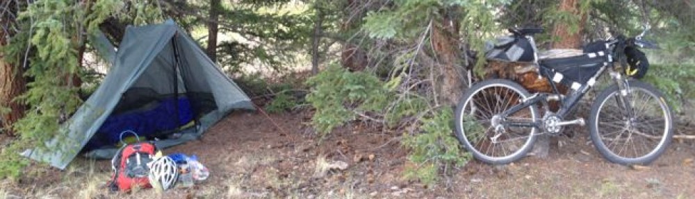
 Here’s a shot of my alpine bike packing camp just before Chochetopa Pass halfway between Salida and Del Norte. Click on any of the photos to enlarge.
Meanwhile in Durango

Stanna high up on the right
Not to be out-done, Stanna and her Wednesday hiking group managed to crest Overlook Point. Her seven friends hiked up above the local 11,400′ tree-line to a point overlooking Ruby Lake, Chicago Basin and the Needle Mountain Range of the San Juan Mountains. Breath-taking, in several senses, this view looking north is one only the hardy get as a reward for their efforts.
This loose group of 20 or more ladies always has between 4 and 12 show up weekly, for various quests around the Four Corners region. They don’t always climb so high, but they alway have a good time exploring hiking routes in the area.
Stanna rarely carries a camera so photo credits go to Linda Crossett and Connie Voss. Below are two more photos from this day hike.

Ruby Lake from Overlook Point

Ruby Lake
By Salida…
By the time I reached Salida in the mid-afternoon of the third day, my butt was talking to me, and I’d already decided that I’d look up a close friend of the Georges (my sister’s family) who lived in town and often put up travelers who pass thru. It was a great decision as I not only got a good rest, excellent home-cooked Salmon Packet meal, but realized I could purchase some “butt butter” in the cycle shop two doors down from her apartment.
 I’d, once again, met two cyclists just as I entered the crux intersection to Salida. These two 21-year-olds from California were doing the entire Great Divide route as a summer training exercise for their college cycling season. They asked, after learning I was from Durango, if I knew any of the Fort Lewis College racers they competed against. (FLC has a nationally known, highly competitive team). They also encouraged me to head out with them, but fortunately I needed re-suppling and a good night’s rest. They evidently are only averaging 70 miles a day, so I figured I might catch them, but never did.
I was continually surprised to learn, upon asking, that no one seemed to know how much weight they were carrying. As you can see from the photo they had quite a load as well. My base weight was 12.5 pounds – “Skin-out” total, without food and water, was 16.5 pounds. Add in 15 pounds of consumables, of which 6.5 pounds is water and I had just over 30 pounds on the bike when fully loaded. Fortunately my weight would go down by 2 pounds for each liter of water I drank.
One provisioning trick I learned purely by chance was to buy a foot-long Subway sandwich in the towns I passed thru and use half for dinner and the other half for my breakfast (breakfast being after about an hour early morning cycle). The energy pick-up I got shortly after half a Buffalo Chicken special was remarkable. And half a Subway was little more than the cost of a granola bar in the convenience stores.
Humbled

One morning I realized I wasn’t cycling alone
In Durango we forget about long shadows in early mornings and late evenings. This morning I wanted to photograph my shadow with my iPhone (not an easy task just getting the Ap turned on, let alone framing a photo). Fortunately one is worth showing here.
By day three I was feeling almost cocky, having knocked off almost 200 miles in two days and as I came into the waypoint town of Hartsel, Colorado I saw another cyclist coming the opposite direction toward that same intersection. We met up and I asked if he was perhaps the Italian racer I’d noticed on the Great Divide website who was since coming north. He said, “No, I’m Austrian and my wife (pointing down the road south) is from Switzerland”. He was more fully loaded with panniers than any tourer’s we’ve seen, rigged with both Ortlieb front and rear panniers, a large Ortlieb duffle on the rear rack as well as a handlebar bag and a frame full of water bottles. His wife had the same set-up when she arrived.
 Of course I asked where and when they started, and immediately felt like my previous two days were meaningless in comparison to their cycle from Patagonia heading for northern Canada. It was also interesting to note that they were sporting German 14 speed internal hubs with a single front chain wheel.
First Camp Great Divide Ride

First Camp on private land at dusk after about 108 miles and 2 passes from Kremmling
Second day was the longest at somewhere over 108 miles. (My odometer bellied up in the rain the first day so I don’t have an accurate measure other than using the maps.) It’s easier to ride long days when you’re solo, have great distances to cover, prefer to find some camp with trees, and the late afternoon thunderstorms are brewing. Rather than set up a camp and sit out a passing storm I often opted to ride though until about 7 PM hopefully skirting the storm and reducing my “tent-time”.
By this time I was surprised to learn that the Great Divide route was primarily on back county roads, Forest Service and old logging roads. I’d envisioned single and double track segments which really aren’t included, unless to regard the narrow line thru miles of washboard roads as single track. As many forums and articles said you don’t need a FSR mountain bike for this route. My “craigslist” aluminum road bike (which I treated as a rental car in Thailand) would have navigated all the roads dispatched by the Great Divide trail maps. This was by no means a disappointment, just a frank realization that almost anyone can traverse this course, given motivation, time, water and food.

South Park
For example crossing South Park on a back road is a long, long open plain. Fortunately I was able to traverse it early in the morning before the strong winds fetch up. I’d heard from the Warmshowers travelers that this section in the wind was a 6 MPH grind.
Great Divide Breckenridge

Climbing to Boreas Pass
First rain I encountered was leaving Breckenridge. It was actually easier to make the climb in the light rain rather than in hot sun. I chanced to be riding the same day and time as the Breck 100, an endurance race similar to the Leadville 100 in early August. The Breck 100 mountain bike riders took a single track route up to Boreas Pass but on their return from Como (the 80 mile mark) they rode uphill against my downhill descent. I first saw them

Notice the Breck 100 racer climbing across the grass to the right of the water tank
climbing near the historic Baker’s Tank and then got the climber’s royal treatment at the 11,482′ Boreas Pass aid station. Bananas, gel and watermelon were all free to me as though I had a number plate on my handler bars. The long 10-mile descent went quickly as there was a continuous stream of racers coming up the same road.

Boreas Pass where aid station volunteer fed and photographed me
First day – Great Divide ride

It’s hard to include yourself in a photo
First day started out wonderfully, it was so easy I couldn’t believe that I was actually riding the Continental Divide Trail. But by 2 PM it got tougher for two reasons: first it started to rain and second the terrain got a little steeper.
I hoped to get past 50 and maybe even 60 miles today, but with the rain I went ahead and rode in the rain and that got me all the way to Kremmling, Colorado. First day mileage was 82 miles in 10 hours.

From Ute Pass you can just barely see the Colorado River headwaters
One of the many highlights was seeing the headwaters of the Colorado River from up high. I must’ve crossed the Colorado three or four times, I lost track. And I didn’t realize that they have rafting out of Kremmling on the Colorado.
The old Cannondale super – V is holding up but it sure squeaks, it makes a lot of noises.
– Posted using BlogPress from my iPhone
Steamboat Springs
 Stanna shuttled me up to Steamboat where I plan to start my Great Divide ride. Rather than ride the Colorado Trail this week I got an interest in riding a segment of the Great Divide trail across Colorado, thanks to two recent Warmshowers.org riders we hosted.
We chanced on having two California teachers finish their GD ride in Durango and after talking to them, I thought this route might suit me better. I won’t be able to send photos with my blog entries as I haven’t gotten that sorted out yet. (the developer didn’t get back to me with a solution to my software issues)
So hopefully I can get a few missives out along the way, when I find wireless.
– Posted using BlogPress on my iPad
Train Hike
Riding the train to the trailhead is something different we wanted to try. Especially since the train goes thru our wilderness area.
 We bought a Durango & Silverton Narrow Gauge Railroad season’s pass for 2012 and finally managed to use it. Our plan is to use the train to access trailheads into the Weminuche Wilderness that aren’t available to use via roads and highways. Our first venture was just to see what the process of booking, boarding and transiting with the train involves. Easier than we figured, excepting that it’s at least a couple hours train travel to even the first wilderness stop.
We picked the shortest hike out on the Fourth of July because we planned a family BBQ on the condo deck. So we took the train to Cascade and hiked up the 4.5 mile Purgatory Trail which is primarily uphill from the Animas River in the Weminuche Wilderness. This trail hasn’t been one of our regular hikes because hiking down and back up isn’t generally a popular route, but with the train we cut the travel in half and were fresh for the uphill.

Cool Break
We both took our ultra lite umbrellas hoping that we’d see some rain and get to test them, however, as much as we saw dark black skies and heard thunder we never got a drop of rain. Surely will have plenty of opportunity as the monsoons start in July


