Back in the Desert

p1430712
img_6385We managed one more 4-Day trip to the desert the last week of October. All three of us were eager to test some new gear and enjoy the end of our Indian Summer here in the Southwest.  The Utah desert is very popular this time of year and securing a backcountry hiking and camping permit is difficult in the Canyonlands National Park.


nationalparkWe learned in Spring that we could come into the very bottom of the National Park (green shading) as day hikers, by entering and exploring the Butler Wash Wilderness Study Area directly south of the park. This area is some of the finest desert wilderness and deserves it’s special designation.

p1430695The only footprints in the four days were deer, bear and bobcat  (excluding the day hikes deep into the National Park where we only saw one set of human prints). Water sources are the primary reason no one goes into this region, but we’ve now scouted and recorded a number of water holes. Our trip itinerary is dependent on finding adequate water and each time we’re able to explore new canyons and routes until we run low and have to backtrack.

wf-ge

10/25/16 East Fork of West Fork Salt Creek


img_6400Because we’ve seen numerous bear tracks and scat in the drainages that we travel and camp, we always hung our food.

Will and Mike both had new packs to test.  Mike’s was a new version of zPacks “front zip” backpack, and Will is always testing and reviewing new pack designs for Gossamer Gear. This trip Will’s pack was a new, soon to be released, 55-liter lightweight backpack. I was able to test out my newest ultralight shelter with it’s dual doors open. However the very best addition was bringing a new UL 1.75 oz pillow. The pillow combined with a “hip hole” in the sand made for the most comfortable sleep I’ve ever had on the ground. Overnight temps were 40° and daytime temps were low 60’s, perfect weather for desert exploring.

img_6386

Typical camps.
p1430681

Our track went thru narrow drainages and over bands of layer rock formations.p1430689

p1430739

As usual, a Good Time was had by All. And in little over 4 weeks we’ll be in Thailand.

img_6399

Reworked my UltraLite Gear page and added an online UL Gear worksheet in case you’re curious.

Fun with Fotos

For those of you in the Mac world, the newest update to Photos has some very interesting “recognition” features. It’s had pretty good facial recognition in the past, but that feature has been taken to another level, Object recognition now spots things like trees, boats, beaches, bicycles, mountains and more. Another remarkable feature takes faces, dates, or a location and makes a “Memory” album from it’s recognition capabilities.

sample-beaches

This can be helpful in finding a photo when you can’t remember the date. Or if you’re just curious to see how many beach photos you’ve got in your library by simply typing in “beach” in the Search area.


search

You can’t imagine how many “boats” the Search function located in my library. It even distinguished between sailing boats and boats in general.


Another feature that’s been around for a while in Photos is the ability to find a photo by location.  If you’re using an iPhone or camera that has geo-location, Photos puts those photos on it’s world map.

sample-places-us

zoomeedinYou can zoom the map to more detail expanding a country, a state, a national park to see where each photo was taken. Yes, geo-location on photos posted on Facebook or Instagram may be problematic if you don’t want someone tagging your home, but for travel and adventure it’s  a real advantage.


I’ve used the object identification to find a specific bike packing rig I used on the Great Divide ride for example. With almost 25,000 photos in my photo library at this time it’s helpful. It’s uncanny how the software can suss out a bike wheel, or handlebars.

sample-bicycles

One new feature I’d never imagined is how the updated Photo App puts together “Memories” albums that are complete slideshows with music and titles based on a location, time period or most amazingly on two or more people, selecting only photos based on those selected people’s faces.groups

june6Photos (the application) selected a trip in 2010 that McKenny’s and Kurt and Carol were on for a “memorable” slideshow for example. What a super surprise and joy to see a slideshow featuring friends from over 6 years ago. You can change the title and/or the music with a click if you’d prefer a better title than “June 6”.

If you haven’t explored this new version of Photos in OS X Sierra you’ve got a wonderful treat coming.


Mostly Social

Mostly social things have kept us close to home lately. Chris George had his 78th and is in good form. Great fun catching up with friends and hearing about their travels and families.

img_6325

img_6300Lots of tech support and a couple days working on a rental.

Spent a Saturday doing a local Solar Home Tour with Carol Martin, where we learned something at every one of the 9 homes we visited. Saw installations on million dollar homes, an off the grid earth home and an Air B & B rental not to mention regular single family homes.  (BTW our latest installation is cranking out plenty of kW’s)

Most unusual home was built by an former Intel engineer that had almost every energy trick you could think of, including what he called a “battery” of hot water storage in 3 levels of Pex tubing under his garage cement floor.

img_6298Speaking of unusual, Mike Taylor needed help removing a pack rat nest in the ventilation cowling of his engine compartment.  Toyota wasn’t interested in taking that part of his newer truck apart evidently. The nest was about 8 inches in diameter and the rodents had dragged all sorts of things up into that secluded home.  A  missing glove was funny, but the book of matches was just plain weird.

A couple of arduous day hikes kept the legs limber, but nothing overnight on the calendar until later in the month when we’ll head to the desert. Eager to test out a couple of newer UL acquisitions.

Packing Light

4monthsthailand

Lots of mention in this Blog about UltraLight backpacking, but the core philosophy is packing light and making clothing and gear work for multiple uses.

img_7345Packing light seems smart, intuitive, and sensible, but after watching countless tourists and travelers tote and carry humungous roller bags and huge backpacks (some also with daypacks on their chests), or try to stuff oversized carry-on bags into airline compartments, it’s worth a rant on packing light. We travel for 3 weeks with less than 14 pounds and for 4 months with less than 25. All of this in a day pack.

Core Principles:

  • Weigh every item
  • Keep a list of item weights
  • Make each item serve multiple purposes
  • Plan to hand wash items that will dry overnight
  • Shop with weight in mind
  • Choose a bag for comfort and convenience not one to fit everything into
  • Roll your clothing
  • Compartmentalize your gear
  • Keep in mind you can wear the same outfit every day
  • Take a photo of your “pile” before you pack for future reference

Scale
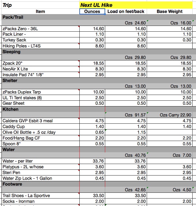
One of the best techniques for Packing Light of course is a kitchen scale. Available from Walmart to Amazon for less than $20, you can know empirically which of your items weighs less than another and worth packing.

Of course, unless your memory is photographic or you indelibly mark (like children’s camp clothing) the weight on each item, you’re going to have to write it down. You can be compulsive like me and keep an excel spreadsheet, or on the back of a junk mail checklistsampleenvelope like your passwords. There are even apps for logging your gear. The main thing is write it down. Choosing between two tops or shirts becomes much easier when you know the which one is lighter.

Mixing and matching is touted by all the fashion cognoscenti, why not make your travel choices work together, with gear as well as clothing. One example might be an iPad that can be used for reading, travel guide, internet, email, movies, camera, showing photos of “home”, blogging and notes. We’ve loaded Lonely Planet & Swiss hiking guide books in Kindle App so that we don’t carry those thick and heavy tomes in our load. Zip-off pants can serve as long pants for churches or shorts for warmer weather.  Believe it or not, Merino Wool base layer shirts can work in cold and warm weather. If you try IceBreaker for example I’ll guarantee you won’t care whether it’s Norway or Moab.

clothesunpackedWe plan on hand-washing most of our clothing while traveling, so that means selecting items that are typically wrinkle-free, will wring out easily and dry fast. Cotton t-shirts don’t fit in that category. A simple short sleeved collared cotton shirt will dry much faster than a t-shirt, will upgrade your casual appearance and store smaller. All these shirts and pants on the left fit in my day pack, along with plenty of other gear for a multi-month trip. All our choices can be washed in a bathroom sink (with hand soap) and dried overnight. Wool socks can be the only difficultly in cold climes and wringing them out inside a towel will extract most of the moisture before you put them next to a heater.   Two pairs will allow for a 2nd day’s drying time. We’ve even slept on the damp socks overnight to completely dry them.

Of course buying and owning lightweight, wrinkle-free, fast drying clothing is best. The biggest objection to ultralight backpacker wannabes is the cost of outfitting, but if you just keep in mind with every new or next acquisition the UL or Lightweight requirements, you’ll have what you need in the matter of a few years, if not a couple of trips or birthdays.

First thing to learn in the UL world is don’t believe the advertising, sale person or marketing when it comes to their concept of “lightweight”.  I once had a reputable backcountry salesman tell me his bivy sack (a nylon tube for your sleeping bag) was ultralight and it weighed more than my 2-person tent.  Check the specifications, bring a scale to the store or keep the sales slip and weigh it after you get home.

We use Osprey day packs, Talon 22’s (top photo) or an older 24-liter pack. Hard to believe but you can get enough for a 21-day trip including electronics in easily. Stanna even takes three pairs of shoes (two pairs in the pack, one pair on her feet). Below is the photo of my clothing and gear for our latest 21-day hiking trip to Switzerland.  Plenty for air travel, eating in good restaurants, and hiking in mountains with snow.

21daysswitzerland

swisscubepacksAs you can see, I learned from the days of the airline “stewardess” that the most efficient way to pack is to roll your clothes. Using a velcro strap is the OCD version of rolling. In addition, we compartmentalize our load with Eagle Creek Cubes which help to compress the load and slide easily in and out of the packs.

Give it a try on your next trip, whether flying to Europe, Asia or your next high country overnight. Once you start thinking lightweight the trips will become easier and you’ll be wondering why tourists have a rolling mini-trunk behind them or that young traveler needs that tortoise-sized pack on his back plus the day pack in front.

Catching Up

img_5912img_5918Catching up with friends, chores, mail, exercise and getting back into our routine.  Best was a weekend visit with McKenney’s in Ridgway, with Kurt & Carol and us driving north to stay with them.  Good friends, good food and good hikes.  Kurt isn’t shown because he took the best photos and shared them for the blog.

Drive and hiking was spectacular due to a recent snowfall above treeline which accented the fall colors with white mountain tops on the three mountain passes north to Ridgway.


img_5881

We’re used to seeing various shades of Fall yellow aspens, but this year the red-leafed aspens were at their best.

img_1746

One indication of time going fast is needing to renew your passports.  We’ve got our request in for another 10 years.  Hopefully the 52-page version will last this decade.

webcamThe Gilmakra Loom is gone and the living room is almost back to normal.  Still lacking a coffee table.  Stanna will order a smaller 24″ loom to replace the behemoth 48″ 10-headle model. And, it’s time to shut off the deck watering system and pull the plants, as a freeze is promised for next week.

Hardest thing has been getting back to the gym routine after 3 weeks.  Spinning and yoga has felt foreign to the body this last week. I did squeeze in a WIS hike in the LaPlatas with my UL buddies before the snow gets more serious.  Looks like “one more summer” has gone.

img_6250

And if you haven’t upgraded to iOS 10 and Mac OS X Sierra, they are welcome upgrades. And I’m very pleased with the iPhone 7: It’s waterproof which should save me considerable trouble and expense.

img_5790Oh, and the solar array for C-1 finally got energized with the power company, so we have another 3.5kW contributing to renewable energy.

Happy to help or advise on installing your own solar system.

Zermatt 2016

We’ve always tried to finish out Swiss adventures in Zermatt primarily because there is a fondue restaurant that has been a Birthday tradition. As this trip was focused on day hiking so that folks might want to join us this year, we’d allowed three days’ hiking in Zermatt. This gave us an opportunity to take trails that we’d never been on in the past.

Similiar to our tracks in Grindelwald, we basically found trails in the four quardents of the valley and were able to view Zermatt and the Matterhorn from various angles, heights and terrain. Not many folks on the trails like in the other regions, probably because Zermatt offers so many modes of uphill travel – trains, funiculars, gondolas, chairlifts and cabinas.

Zermatt, and viewing it’s Matterhorn, is on the world tourist’s bucket list. Most are here for selfies, DSLR classic photographs and checking off the list, so there isn’t as much interest in hiking per se. Which makes for virtually empty trails despite the tens of thousands visiting town daily.

It had snowed above 8,000′ the days before our arrival, and the first morning our hike was in dense fog and snow on the trails. For only the third time in 3 weeks did we don our raingear. We snapped a lot of Matterhorn photos ourselves, never knowing if this glimpse would be our last.

Zermatt’s heavy tourism makes for intriguing people watching.  As a private car-less community the narrow streets are all basically walking streets. The winning feature was this extremely quiet street vacuum.

It was very rewarding to look from the other side of the valley and see and identify our routes high across the opposite mountains.
We did visit our favorite restaurant for their other fondue speciality before we left.

Murren

Murren is one of those “supposedly” car-less villages high up from the valley above Lauterbrunen still in the Bernese Oberland. It’s quite popular for hiking but most famous for it’s gondola to the Schlithorn observation point perched atop Piz Gloria. It’s also directly across from Wengen, another cliff side community accessible only by cog railway.

Back in the 70’s before there were the ubiquitous Swiss trail signs there were only yellow and blue paint stripes on exposed rocks in the alp (remember an alp is the grassy meadow between the rocks, cliffs, peaks and palisades). Three of us were backpacking (frowned upon even then) up from Kandersteg toward Grindelwald, when in dense fog we lost track of our route only to come up on the backside of the massive Schlithorn gondola station and restaurant.  Not sure who was more shocked, us or the few tourist out on the observation deck seeing us appear one by one like apparitions out out the mist.

We hiked thru Murren when we hiked the Via Alpina two years ago and wanted to visit and hike some adjacent trails.  Weather has been outstanding for the first 14 days, but the mountains finally let in a low pressure system of fog and drizzle.  With our UL rain gear we had no problem enjoying a 9 mile hike and 2,800′ ascent. Best was trying out our new zPacks rain skirts, which turned out great: far easier to put on than rain pants and no problem climbing or descending rocky trails.

Forgot Locarno

How could we forget Locarno in the southern lake district of Switzerland. We only took one alpine hike in the area but we wanted to see what the Italian version of hiking was like & it was very rewarding. First I should say that the the train rides in and out of that area are spectacular. They are part of the Glacier Express, an exclusive panoramic rail tour from St Moritz to Zermatt. Although we didn’t travel on the actual Glacier Express cars, we traveled a regional train on the same rails in a different style without white table cloths and waiters, catered service and meals.

Locarno is a truly Italian town; although the Swiss people are educated with three languages there’s hardly any evidence of anything but Italian spoken in this region. It has a true Mediterranean feel, warmth and altitude. Definitely an urban environment, lots of people in high density, but it’s easy to get out of the city and quickly into the mountains which provided great hiking and wonderful views.


What was unique on this particular trip and hike was we got to hike through a number of stone villages and past farm houses. Many are no longer occupied and some are partially occupied with upgraded amenities but all of them are far away from roads with access by trails and aerial tramways in which to get supplies only up to these remote alpine locations.

Saturday night in the main plaza they had a Risotto Rice food festival at which all the hotel chefs created their fanciest risotto rice dishes.  We chose to try a quinoa burger instead.


Here’s our track in case you’re interested.

Lost Track

 I’ve lost track.  Fortunately GaiaGPS knows where we are and what we have done. Thirteenth day of travel and hiking and it’s getting hard to figure what to feature on the blog. Currently we’re in the Grindelwald valley, our fourth day here and we’ve done a number of hikes that we have never done before, several really notable hikes including one below the north face of Eiger and another panoramic view of the entire Grindelwald valley.


I’ve been coming to this valley since 1975 and I’ve never gotten up close and personal with the Eiger north wall like we did this time.  They just recently placed these maps showing the climbing routes, this one the original climb in 1938. Was really fun to look at the map and look at the wall and actually see where a climber may have actually gone and how they get to the top. The current record for climbing this wall is two hours and 20 minutes by a solo Swiss climber.


In many past times the peak of the Eiger was shrouded in clouds like any high peak in Switzerland. This trip we’ve been able to see the Eiger clearly in blue skies which are often called Swiss calendar days. On our third day here we took the panoramic hike high on the northeast side of the Grindelwald valley from Schynige Platte to Grosse Scheidegg. 


With little or no wind, the humidity and pollution from the valley comes up and leaves a little bit of “marine or atmospheric” layer clouding the view, but it is still outstanding. This trail is so popular because they have a funicular train that takes you to the beginning and you can take a gondola off the other end.


Three more days here and Murren and then we’re in Zermatt.

Vals Therme

The real reason we came to Vals was the check out the baths. Daniel learned of the Therme because it is an example of famous Swiss architecture; he has visited & told us that we should visit too.


These several photographs don’t begin to do it justice as we spent over two hours wandering through the various rooms and chambers experiencing a variety of water temperatures, chambers, chimes and scented water before I even thought to take photographs. It must be about a 20,000 square-foot building with more than half of that dedicated to water features.

One dark tiny stone room (with 20′ ceilings – which was the architectural standard) had a low padded bench where you accidentally discover a head rest at one end and you lie down to a bell and chime soundtrack. Anyone familiar with Shavasana could immediately assume the pose and fall into that resting trance some call the corpse pose.

Oh, and then we must have visited the 42* hot water chamber at least four times, between fragrant water pools, the steam rooms in three increasing degrees, or the waterfall massage spouts, to mention a few.


This experience could be the most relaxed I’ve ever been, or at least in 100 years. It was hard to leave one room and explore finding another as they are virtually unmarked and very subtly presented. The mineral waters are so clear and calming you move in slow motion in the waters as well as between the rooms. The entire structure is designed with Vals stone, quarried locally. It’s very hard not to want some of these water features in your own home or at least in your own town.

Vals

Here is the link to the Public GaiaGPS https://www.gaiagps.com/datasummary/track/d2c6b5406cfd473fc42128935deb336d/ where you can learn more about our track and see other tracks in the vicinity.

Only one hike in the Val’s region.  Posted above is the link to it on GaiaGPS’s website.  This is an experiment to see how this looks on blog.


Another experiment was taking a timer photo on my hiking pole.

You have to look close for the blue phone case on the pole.